You can Download Samacheer Kalvi 10th Social Science Book Solutions Guide Pdf, Tamilnadu State Board help you to revise the complete Syllabus and score more marks in your examinations.
Tamilnadu Samacheer Kalvi 10th Social Science Geography Solutions Chapter 5 India: Population, Transport, Communication, and Trade
India: Population, Transport, Communication, and Trade Textual Exercise
I. Choose the correct answer.
Question 1.
The scientific study of different aspects of population is called ……..
(a) Photography
(b) Demography
(c) Choreography
(d) Population density
Answer:
(b) Demography
![]()
Question 2.
The state with highest literacy rate as per 2011 census is:
(a) Tamil nadu
(b) Karnataka
(c) Kerala
(d) Uttarpradesh.
Answer:
(c) Kerala
Question 3.
Human Development is measured in terms of …….
(a) Human Resource Index
(b) Per capita index
(c) Human Development Index
(d) UNDP
Answer:
(c) Human Development Index
![]()
Question 4.
…………………. transport provides door to door services.
(a) Railways
(b) Roadways
(c) Airways
(d) Waterways.
Answer:
(b) Roadways
Question 5.
The length of Golden Quadrilateral superhighways in India is
(a) 5846 km
(b) 5847 km
(c) 5849 km
(d) 5800 km
Answer:
(a) 5846 km
![]()
Question 6.
The length of navigable Inland waterways in India is:
(a) 17,500 km
(b) 5000 km
(c) 14,500 km
(d) 1000 km
Answer:
(c) 14,500 km
Question 7.
The National Remote sensing Centre (NRSC) is located at
(a) Bengaluru
(b) Chennai
(c) Delhi
(d) Hyderabad
Answer:
(d) Hyderabad
![]()
Question 8.
The transport useful in the inaccessible areas is:
(a) Roadways
(b) Railways
(c) Airways
(d) Waterways
Answer:
(c) Airways
Question 9.
Which of the following is associated with helicopter services?
(a) Air India
(b) Indian Airlines
(c) Vayudoot
(d) Pavan Hans
Answer:
(d) Pavan Hans
![]()
Question 10.
The major import item of India is:
(a) Cement
(b) Jewells
(c) Tea
(d) Petroleum
Answer:
(d) Petroleum
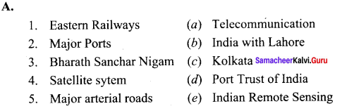
II. Match the following.
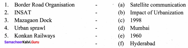
Answers:
1. (f)
2. (a)
3. (d)
4. (b)
5. (c)
III. Answer the following questions briefly.
Question 1.
What is Human Development?
Answer:
Dr Mahabub-ul-haq defined Human Development as “it is a process of enlarging the range of people’s choice, increasing their opportunities for education, health care, income and empowerment. It covers the full range of human choices from a sound physical environment to economic, social and political freedom”.
Question 2.
What is migration? State its types.
Answer:
It is the movement of people across regions and territories.
- Internal migration and
- International migration.
Question 3.
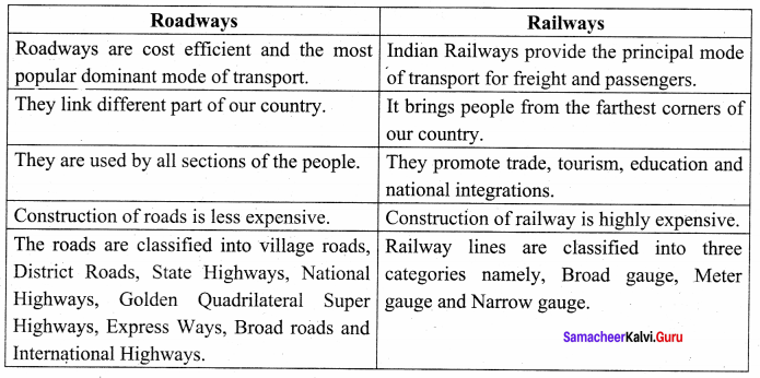
Write any four advantages of railways.
Answer:
Advantages of Railways:
- Cater to the needs of large scale movement of traffic for freight and passengers.
- Promotes trade, tourism, education etc.
- Promotes National integration by bringing people together.
- Facilitates the quick movement of perishable goods.
![]()
Question 4.
Write a note on Pipeline network transport in India.
Answer:
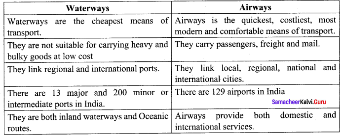
Pipelines are used for transporting crude oil, petroleum products and natural products and natural gas from oil fields to the refineries, factories and big thermal power plants. Pipelines are more reliable and considerably safer mode of transportation. The possibility of pilferage or product less on pipelines is almost negligible. The basic limitations of pipelines is that they are capital intensive mode of transportation.
![]()
Question 5.
State the major Inland waterways of India.
Answer:
- Ganga – Bhagirathi – Hoogly river system between Haldia and Allahabad.
- Stretch of the Brahmaputra river between Dhubri and Sadiya National Waterway.
- The waterway between Kollam and Kottapuram – the first national waterway.
Question 6.
What is communication? What are its types?
Answer:
Communication refers to exchange of ideas, messages, emotions, either written or oral, from one place to another.
Types of communications are :
- personal communication and
- mass communication.
Question 7.
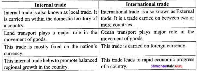
Define “International trade”.
Answer:
Trade carried on between two or more countries is called “International trade”. It is also called as external trade or foreign trade. It has two components Exports and Imports.
![]()
Question 8.
State the merits of Roadways.
Answer:
- Cost of construction of roads is much lower.
- Provides door to door services thus the cost of loading and unloading is much lower.
- Used as feeder to other modes of transport to reach any destination be it railway station, sea port or airport, one need to travel through roads.
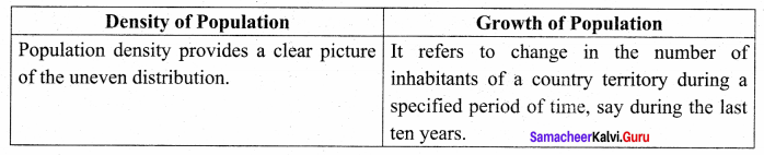
IV. Distinguish between.
Question 1.
The density of population and growth of population.
Answer:
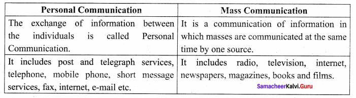
Question 2.
Personal communication and mass communication.
Answer:
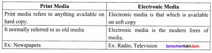
Question 3.
Print Media and Electronic Media.
Answer:
Question 4.
Roadways and Railways.
Answer:
Question 5.
Waterways Airways
Answer:
Question 6.
Internal trade and International trade.
Answer:
V. Answer the following in a paragraph.
Question 1.
What is urbanization? Explain its impacts.
Answer:
“The process of society’s transformation from rural to urban is known as urbanization”.
Impacts of Urbanization:
- Overcrowding in urban centres.
- It creates urban sprawl.
- It leads to the formation of slums.
- Shortage of houses in urban areas.
- It creates water scarcity in the cities.
- It creates drainage problem.
- It poses the problem of solid waste management.
- It increases traffic congestion in cities.
- It increases the rate of crime.
A rapid rate of urbanization in society is taken as an indicator of its economic development.
Question 2.
Explain the importances of satellite communication in India.
Answer:
Satellite images are used for weather forecasting, monitory of natural calamities, surveillance of border areas etc. The communication through satellites emerged as a new era in communication in our country after the establishment of Indian Space Research Organization (ISRO) in 1969. Satellite systems in India can be grouped into two on the basis of two satellites namely “Indian National Satellite” (INSAT) and “Indian Remote Sensing Satellite” (IRS). These satellites collect data in several spectral band and transmit there to ground stations for various uses. The communication and remote sensing satellites INSAT and IRS have revolutionized India’s communication system. Metrological studies and natural resource management.
The National Remote Sensing Agency (NRSA) at Hyderabad provides facilities for acquisition of data and its processing. There is no doubt that India has irrefatably arrived as a space power in the world. The INSAT series are used for relaying signals to television, telephone, radio, mobile phone. It is also useful in weather detection, internet. The INSAT series GSAT series, GSAT series KALPANA -1, HAMSAT, EDUSAT are the major communication satellite used for communication purpose. GSAT – 7A is the recent launch for communication programs. INSAT – IB launched on 30th August, 1983 is the first communication satellite in INSAT series.
![]()
Question 3.
Bring out the distribution and density of population in India.
Answer:
The term “Population Distribution” refers to the way the people are spaced over the earth’s surface.
The distribution of population in India is unevenly distributed due to the vast variation in the availability of resources.
Factors that affect the distribution of population are: Terrain, climate, soil, water bodies, mineral resources, industries, transport and urbanization.
Areas of high concentration of population: Industrial centres and the areas of good agricultural lands.
Areas of thin population: high mountains, arid lands, thickly forested areas and some remote comers and some areas are even uninhabited.
Most populous states in India: Uttar Pradesh is the most populous state in India (199.5 million) followed by Maharashtra (112.3 million), Bihar (103.8 million) West Bengal (91.3 million) and the combined Andhra Pradesh (84.6 million).
Least populated State: Sikkim (0.61 million).
Union territory with high population: Delhi (16.75 million). Union territory with least population – Lakshadweep (64,073).
Question 4.
Explain the process of measuring Human Development.
Answer:
Dr. Mahabub – ul – Haq defined as “It is a process of enlarging the range of people’s choice, increasing their opportunities for education, health care, income and empowerment”. Human
Development Index (HDI) is a composite index focusing on three basic dimensions of human development.
- Health – life expectancy at birth,
- Education – expected years of schooling for school age children and average years of schooling for the adult population,
- Income – Measured by gross national income and per capita income.
![]()
Question 5.
Classify and explain the roadways in India.
Answer:
Roadways play an important role in carrying goods and passengers for short, medium and long distances. It is highly suitable for short-distance services.
For the purpose of construction and maintenance Roadways in India are classified into:
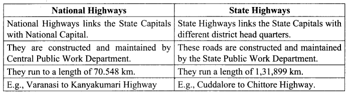
- National Highways (NH)
- State Highways (SH)
- District Roads
- Rural Roads (Village roads)
- Border Roads
- International Highways
National Highways:
- Ministry of Road Transport and Highways of India is responsible for the development and maintenance of the National Highways in India.
- These Highways are connecting capitals of states, major ports, rail junctions, industrial and tourist centres.
- The total length of the National Highways in India is 1,01,011 Km which accounts for 1.8% of total road network length in 2016.
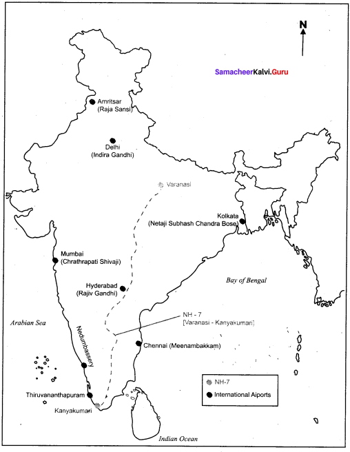
- The longest National Highway NH-7 runs from Varanasi (U.R) to Kanyakumari (T.N) to a distance of 2369 km.
- The shortest National Highway is NH-47A, runs from Emakulum to Kochi port (Willington Island) covering a distance of 6 km.
State Highways:
- These roads are administered and financed by State Governments.
- These highways link important cities, towns and district headquarters within the state and connect them with national highways or highways of neighbouring states.
- State highways run to a length of 1,76,166 km as of 2016.
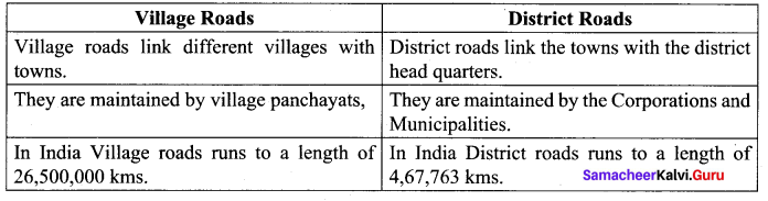
District Roads:
- District Roads are constructed and maintained by the Public Works Department of the states.
- District Roads provide connectivity between the district and taluk headquarters with the state highways and national highways.
- The total length of the road is 5,61,940 km in 2016.
- Rural Roads (Village Roads): They are maintained by village Panchayats.
- It links different villages with their neighbouring towns.
- Rural roads connectivity is a key component of Rural development.
- The total length of Rural roads in India is 39,35,337 km as of 2016.
- Rural roads consists of Panchayat roads, (Zilla Parishad, Panchayat Samiti, Gram Panchayat), roads of the Pradhan Mantri Gram Sadak Yojana (PMGSY) and those constructed by the State PWDs.
Border Roads:
- They are constructed and maintained by Border Roads Organization established in 1960 for the development of the roads of Northern and North Eastern border areas.
- These are the roads of strategic importance in border areas.
- The Border Road organization has constructed world’s highest road joining Chandigarh and Leh in Ladak (at an altitude 4,270 mt).
- Golden Quadrilateral: This project was launched in 1999.
- It connects India’s four metropolitan cities Delhi – Kolkata – Chennai Mumbai.
- It has 4/6 lanes and of 5,846 km long.
- North-South and East-West corridors: These two corridors intersect at Jhansi.
- North-South Corridor connects Srinagar in Jammu and Kashmir with Kaniyakumari in Tamil Nadu (4,076 km).
- The East-West corridor connects Silchar in Assam with port town of Porbandar in Gujarat (3,640 km).
![]()
Express ways: These are the multi lane good quality highways for high speed traffic. Eg: (a) Mumbai – Pune Road, (b) Delhi – Agra.
International Highways:
- These Highways have been constructed with an aid from World Bank under an agreement with the Economic and Social Commission for Asia-pacific (ESCAP).
- These roads link India with her neighbouring countries – Pakistan, Nepal, Bhutan, Bangladesh and Myanmar.
India has the second-longest road network in the world.
VI. On the outline map of India mark the following.
1. National Highway NH-7.
3. Major International Airports in India.
2. Major seaports in India.
4. Densely populated state of India.
5. State of highest literacy in India.
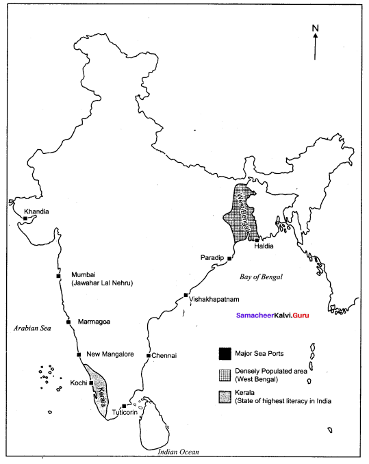
6. Railway zones of India
In-Text Hots Questions:
Question 1.
What could be the reason for uneven distribution of population in India?
Answer:
The uneven distribution of population in the country is the result of several factors such as physical, socio-economic and historical ones.
Physical factors: Relief, climate, water, natural, vegetation, mineral and energy resources.
Socio-economic factors: Religion, political issues economy, human settlements, transport network, industrialization, urbanization, employment opportunity etc.
![]()
Question 2.
What are the reasons for the rapid growth of population in India?
Answer:
- Widening gap between birth and death rates.
- Low age at marriage.
- High illiteracy.
- Religious attitudes towards family planning.
Question 3.
The sex ratio in our country is always unfavourable to females. Give reasons.
Answer:
- Attitude of the people: Prestige and pride in having male child made them to prefer a male child to a female child.
- Female infanticide: Even now in same places it is being done for fear of neglect by their family members if they give birth to a female child.
- Future marriage expenses on female child.
- Considered as weaker sex so will not be given opportunity to prove their ability suppressed by male domination.
Question 4.
Find out what are the functions of NHAI.
Answer:
The functions of National Highways Authority of India (NHAI) are:
- To develop, maintain and manage the national highways and any other highways vested in, or entrusted to it by the Government.
- Survey, develop, maintain and manage highways vested in, or entrusted to it.
- Construct offices or workshops and establish and maintain hotels, motels, restaurants and rest-rooms at or near the highways vested in, or entrusted to it.
- Construct residential buildings and townships for its Employees.
- Regulate and control the plying of vehicles on the highways vested in or entrusted to it for the proper management thereof.
- Provide such facilities and amenities for the users of the highways vested in, or entrusted to it as are in the opinion the Authority, necessary for the smooth flow of traffic on such highways.
- Advise the Central Government on matters relating to highways.
Question 5.
What are the highlights and benefits of the Golden Quadrilateral Highways?
Answer:
The main objective of this project is connectivity, speed and safety.
Connectivity: Connects four major metropolitan cities enhances the movement of goods and people to the industrial areas enhances job development.
Access to hinterland of agricultural areas to market areas, ports for export needs.
Speed: Reduces the travel time.
Safety: Six lanes super highways meant for safety.
This project was launched in the year 1999. Implemented by National Highway Authority of India.
Encourages the private sector companies to invest, develop and maintain these highways.
Question 6.
Why is air travel preferred in the north eastern states?
Answer:
- Due to mountains, rivers, etc. road journey becomes too long even for short distance.
- So air travel is the most feasible option and the costs are also quite low due to subsidies by the government.
- Most of the cities have regional active airports.
- Air transport is preferred mainly in the North eastern states of India.
![]()
Question 7.
Find out the major trade blocks which are useful for multilateral trade.
Answer:
Major trade blocks useful for Multilateral trade.
EU: European Union
APEC: (Asian Pacific Economic Community) .
ASEAN: (Association of South East Asian Nations)
SAPTA: (South Asian Preferential Trade Agreement)
These trade blocks made the international trade easier. All member countries who signed the agreement are treated equally. These trade blocks remove the barriers and complications arose between nations in international trade.
Activity:
Question 1.
Prepare a seminar topic about “Role of Railways in Indian Economy”.
Answer:
Role of Railways in Indian Economy
- Railways are the principle mode of transportation for freight and passengers in India.
- Railways also make it possible to conduct multifarious activities like business, sight seeing, pilgrimage along with transportation of goods over longer distances.
- Railways in India bind the economic life of the country as well as accelerate the development of industry and agriculture.
- The distribution pattern of the railway netw ork in the country has been largely influenced by physiographic, economic and administrative factors.
Question 2.
Collect the names for different types of goods and differentiate it and make a table as perishable and non-perishable goods.
Answer:
Perishable goods are foods like fresh meat, seafood, and ripe fruits.
Non-perishable are items that do not spoil or decay.
Ex. Canned goods, all pasta types, sugar, flour, curls and chips if air-sealed.
Question 3.
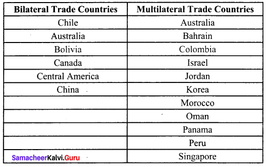
Collect the countries names and make it as a table of Bilateral trade and multilateral trade countries.
Answer:
Find Out:
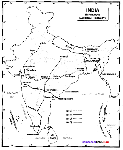
The important National Highways in India and label it on the outline map of India.
The important National Highways in India are:
NH-6- Hazira to Kolkata (via Nagpur, Raipur, Sambalpur and Dhule)
NH-7 -Varanasi to Kanyakumari (Nagpur, Bangaluru and Madurai
NH-8 – Delhi to Mumbai (Jaipur, Ahmedabad and Vadodara)
NH-9 – Pune to Machilipatnam and Hyderabad, Vijayawada
The important National Highways in India.
India: Population, Transport, Communication, and Trade Additional Questions
I. Choose the correct answer.
Question 1.
India is the ……. most populous country in the world.
(a) first
(b) second
(c) sixth
Answer:
(b) second
![]()
Question 2.
The …………………. is the least populous state.
(a) Assam
(b) Goa
(c) Sikkim
(d) Arunachal Pradesh
Answer:
(c) Sikkim
Question 3.
Postal service and telegraph are some of the ………. communication.
(a) personal
(b) professional
(c) mass
Answer:
(a) personal
Question 4.
In India the year of demographic divide registered negative growth rate is ………………….
(a) 1921
(b) 1931
(c) 1947
(d) 1950
Answer:
(a) 1921
Question 5.
The headquarters of the Northern Railways is ………
(a) Jabalpur
(b) Allahabad
(c) Guwahati
Answer:
(c) Guwahati
![]()
Question 6.
The National Highways Authority of India was established in:
(a) 1975
(b) 1985
(c) 1995
(d) 2005
Answer:
(c) 1995
Question 7.
The first railway line was laid between in 1853.
(a) Delhi and Kolkata
(b) Mumbai and Kolkata
(c) Mumbai and Thane
Answer:
(c) Mumbai and Thane
Question 8.
Indian Railways is organized into …………………. zones for operations and management.
(a) 15
(b) 20
(c) 16
(d) 19
Answer:
(c) 16
Question 9.
Trade blocs are created to make the ……. trade easier.
(a) Multilateral
(b) Bilateral
(c) Local
Answer:
(a) Multilateral
![]()
Question 10.
The …………………. is the fuel efficient and eco-friendly mode of transport.
(a) Roadways
(b) Railways
(c) Waterways
(d) Airways
Answer:
(c) Waterways
Question 11.
The headquarters of Indian Railways is ……..
(a) Mumbai
(b) New Delhi
(c) Nagpur
Answer:
(b) New Delhi
Question 12.
The …………………. are the most powerful means of print media.
(a) Radio
(b) Magazines
(c) Fax
(d) Newspapers
Answer:
(d) Newspapers
Question 13.
The highways connecting the four metropolitan cities – Chennai, Mumbai, Delhi and Kolkata.
(a) Six lanes super highways
(b) Expressways
(c) Border Roads
Answer:
(a) Six lanes super highways
Question 14.
Primitive method of trade was known as system.
(a) communication
(b) barter
(c) bilateral
(d) balanced
Answer:
(b) barter
Question 15.
Metro Rail transport in Chennai was introduced in …….
(a) 2015
(b) 2014
(c) 2005
Answer:
(a) 2015
Question 16.
Since 1957 All India Radio came to be called ……..
(a) Akshvani
(b) Sooriyan FM
(c) Vivith Bharathy
Answer:
(a) Akshvani
Question 17.
The Government of India merged all the Indian Airlines under ………
(a) TATA Airline
(b) National Aviation Corporation of India
(c) Airport Authority of India
Answer:
(b) National Aviation Corporation of India
Question 18.
Which mode of transportation reduces trans-shipment losses and delays.
(a) Railways
(b) Pipelines
(c) Roadways
Answer:
(b) Pipelines
![]()
Question 19.
Which of the following sates is not connected with the H.V.J. Pipeline?
(a) Madhya Pradesh
(b) Maharashtra
(c) Gujarat
Answer:
(b) Maharashtra
Question 20.
Which one of the following ports is the deepest land-locked and well protected port along the
east coast?
(a) Chennai
(b) Paradip
(c) Vishakhapatnam
Answer:
(c) Vishakhapatnam
Question 21.
Which one of the following terms is used to describe trade between two or more countries?
(a) Internal Trade
(b) International Trade
(c) Local Trade
Answer:
(b) International Trade
Question 22.
The National Highway No.l is also known as
(a) Mahatma Gandhi Marg
(b) Sher Shah Suri Marg
(c) Jawahar Lai Nehru Road
Answer:
(b) Sher Shah Suri Marg
Question 23.
Trade carried in cities, towns and villages is called
(a) External trade
(b) Local trade
(c) international trade
Answer:
(b) Local trade
Question 24.
The Indian National Highways are maintained by the department of …….
(a) State Public Works Department
(b) Zila Parishad
(c) Central Public Works Department
Answer:
(c) Central Public Works Department
![]()
Question 25.
Which one of the following organizations constructs Border roads in India?
(a) PWD
(b) CPWD
(c) NHAI
Answer:
(c) NHAI
Question 26.
World has become a global village due to which of the following?
(a) Transport and communication
(b) Engineering Industry
(c) International trade
Answer:
(a) Transport and communication
Question 27.
Border Roads Organization was established in
(a) 1950
(b) 1955
(c) 1960
Answer:
(c) 1960
Question 28.
The longest highways of India is
(a) National Highway – 8
(b) National Highway – 7
(c) National Highway – 1
Answer:
(b) National Highway – 7
Question 29.
Delhi and Mumbai are connected by …..
(a) National Highway – 1
(b) National Highway – 15
(c) National Highway – 8
Answer:
(c) National Highway – 8
![]()
Question 30.
Which Port is the major iron ore exporting port of the country?
(a) Mumbai Port
(b) Marmagoa
(c) Kandala Port
Answer:
(b) Marmagoa
Question 31.
The biggest port is …….
(a) Mumbai Port
(b) Marmagoa Port
(c) Kandala Port
Answer:
(a) Mumbai Port
Question 32.
The extreme south – western port is …….
(a) Tuticorin Port
(b) Kochi Port
(c) New Mangalore Port
Answer:
(b) Kochi Port
II. Fill in the blanks.
1. Our National Integration is strengthened by the ……
2. …… have been replaced by more powerful diesel or electric engines.
3. There are ……… major ports located on the coast line of India.
4. Crude oil, petroleum and natural gas are transported by ……….
5. The largest terrestrial network of the world is ……….
6. The latest means of communication is ………
7. The multi purpose satellite system for telecommunication is …… – INSAT
8. The roadways are able to connect most of the ……… villages.
9. It is easier to construct and maintain ………..
10. National highways are maintained by ……… Government.
11. Indian railways system is the ……… in Asia.
12. Under transport the ….. forms the lifeline of the country.
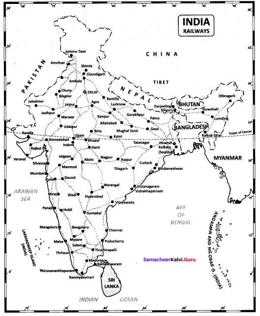
13. The city ……. is the focal point from where railway lines radiate in all directions.
14. River Ganga is navigable upto …….
15. This world has been shrunk since the introduction of ……..
Answers:
1. Railways
2. Steam Engines
3. 13
4. pipelines
5. Doordharshan
6. Satellite
7. Indian National Satellite
8. remote
9. roadways
10. Central
11. largest
12. Railways
13. Delhi
14. Varanasi
15. Internet
![]()
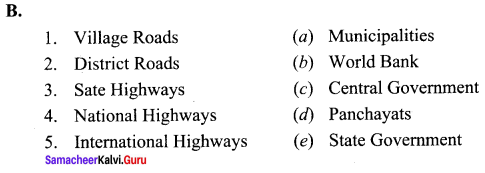
III. Match the following.
Answers:
(1 – c)
(2 – d)
(3 – a)
(4 – e)
(5 – b)
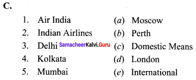
Answers:
(1 – d)
(2 – a)
(3 – e)
(4 – c)
(5 – b)
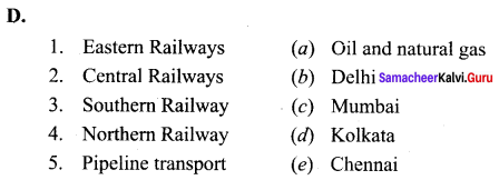
Answers:
(1 – e)
(2 – c)
(3 – a)
(4 – b)
(5 – d)
Answers:
(1 – d)
(2 – c)
(3 – e)
(4 – b)
(5 – a)
IV. Answer in one word.
Question 1.
What provides information regarding the population of our country?
Answer:
The Census of India.
Question 2.
When was the first Census held in India?
Answer:
1872
Question 3.
When was the first complete census taken?
Answer:
1881
Question 4.
After how many years Census is held in India?
Answer:
Census is held regularly after every tenth year.
![]()
Question 5.
Which is the most comprehensive source of demographic, social and economic data in India?
Answer:
Indian Census
Question 6.
What is the population of India according to 2001 and 2011 Census?
Answer:
India’s population size as on March 2001 stood at 1,028 million and in 2011 is 1,210 million.
Question 7.
Which is the most populous state of India?
Answer:
Uttar Pradesh
Question 8.
Which is the least populated state of India?
Answer:
Sikkim
![]()
Question 9.
Which is the least populated region of India?
Answer;
Lakshadweep
Question 10.
Name the five most populated states in India.
Answer:
- Uttar Pradesh,
- Maharashtra,
- Bihar,
- West Bengal and
- Andhra Pradesh.
Question 11.
Define population density.
Answer
It is calculated as the number of persons per unit area.
Question 12.
Which is the least densely populated state of India?
Answer:
Andhra Pradesh with 17 persons per sq.km.
Question 13.
Name the three main processes of change of population.
Answer:
Birth rates, death rates and migration.
Question 14.
Which two countries have a higher average population density than India?
Answer:
Bangladesh and Japan.
![]()
Question 15.
What are various types of migration?
Answer:
Internal migration and International migration.
Question 16.
Define age structure.
Answer:
It refers to the number of people in different age groups in a country.
Question 17.
Define sex ratio.
Answer:
Sex ratio is defined as the number of females per 1000 males in the popultion.
Question 18.
Is sex ratio balanced in India?
Answer:
No
![]()
Question 19.
Which regions of India has the highest and lowest sex ratio as per Census 2011?
Answer:
Kerala has a sex ratio of 1084 females per 1000 males, Delhi has only 866 females per 1000 males.
Question 20.
Who is a literate?
Answer:
A person aged 7 years and above who can read and write with understanding in any language is treated as literate.
V. Distinguish between.
Question 1.
National Highways and State Highways.
Answer:
Question 2.
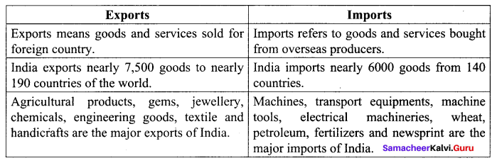
Exports and Imports.
Answer:
Question 3.
Village Roads and District Roads.
Answer:
Question 4.
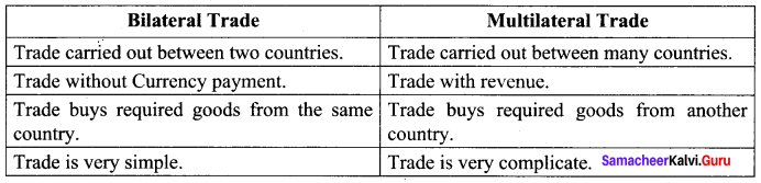
Bilateral Trade and Multilateral Trade
Answer:
Question 5.
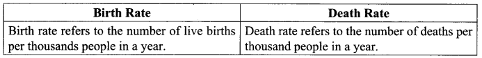
Birth Rate and Death Rate
Answer:
![]()
Question 6.
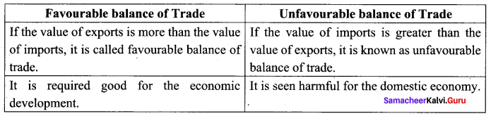
Favourable balance of trade and Unfavaourable balance of Trade
Answer:
VI. Answer the following questions briefly.
Question 1.
What is the position of Indian population in the World?
Answer:
- India is the second most populous country in the world.
- It is the home of 17.5% of world’s population.
- One out of every six persons in the w orld is from India.
- Our population is almost equal to the combined population of USA, Indonesia, Brazil, Pakistan, Bangladesh and Japan.
Question 2.
How is the population of India grouped?
Answer:
The population of a nation is generally grouped into three broad categories.
- Children (below 15 years): They are economically unproductive and need to be provided with food, clothing, education and medical care.
- Working Age (15-59 years): They are economically productive and biologically reproductive. They comprise the working population.
- Aged (above 59 years): They can be economically productive though they may have retired.
![]()
Question 3.
What does the term “population change” refer to?
Answer:
The term “population change” refers to an increase or decrease of population of an area from one period to another period.
Question 4.
Name the three major superhighway project.
Answer:
- Golden Quadrilateral Super Highways: It links Delhi – Kolkata – Chennai – Mumbai and Delhi by six lane Super Highways.
- North – South Corridor: Linking Srinagar (Jammu and Kashmir) and Kanyakumari (Tamil Nadu).
- East-West Corridor: Linking Silcher (Assam) and Porbandar (Gujarat). The major objective of these Super Highways is to reduce the time and distance between the mega cities of India.
Question 5.
Name the three major means of transport in the world?
Answer:
The three major means of transport in the world are:
- Land transport: Roadways, Railways and pipelines.
- Waterways: Inland waterways and ocean routes
- Air transport: Domestic airways and International airways.
Question 6.
What is trade? What are the types of ti;ade?
Answer:
- Trade is an act or process of buying, selling or exchanging goods and services.
- Types of trades are
- Internal trade
- International trade.
Question 7.
Write about the merits of air transport.
Answer:
Airways are the quickest, costliest most modem and comfortable means of transport.
- Facilitates connectivity on a regional, national and international scale.
- Made accessibility by connecting difficult terrains like high mountains and deserts.
- It carries passengers, freight and mail.
- Air transport plays a key role in times of emergency, during the time of natural and man made calamities like floods, epidemics and wars.
![]()
Question 8.
What are the merits of pipeline transport?
Answer:
- It can be laid through difficult terrain as well as under water.
- Initial cost of laying pipelines is high but subsequent cost for maintenance and operation is low.
- It ensures steady supply and minimizes transhipment losses and delays.
- Pipeline operation involves very low consumption of energy.
![]()
Question 9.
What are the different kinds of mail services introduced by Department of posts?
Answer:
- Cards and envelopes are considered first-class mail and airlifted between ‘ stations both land and air.
- The second class mail includes-book packets, registered newspapers and periodicals, carried by surface mail covering land and water transport.
- Recently six mail channels have been introduced to facilitate quick delivery of mails in large towns and cities. They are Rajdhani channel, Metro Channel, Green Channel, Business Channel, Bulk mail Channel
Question 10.
Explain MRTS (Metro Rail System).
Answer:
- The Mass Rapid Transit System is an elevated line of the suburban railways in Chennai.
- This Railway is administrated by the state owned Southern Railway.
- This railway line currently runs from Chennai beach to Velachery covering 17 stations for a distance of 25 km.
Question 11.
What do you mean by Foreign Exchange?
Answer:
Foreign Exchange is the mechanism or process by which payments between any two places operating under different national currency systems are effected without passing of actual money or gold etc.
Question 12.
What are the four ship building yards in India?
Answer:
- Hindustan Shipyard at Vishakhapatnam.
- Garden reach workshop at Kolkata.
- Mazagaon Dock at Mumbai.
- Kochin Ship Yard and Kochi.
Question 13.
Define the term Dependency Ratio.
Answer:
The ratio between the economically active and economically inactive of population is termed as Dependency Ratio.
VII. Answer in a paragraph:
Question 1.
Define population. Why there is a need to study population?
Answer:
- The total number of people residing in a country at a specified period of time is called “population” of that country. The study of population is known as Demography.
- The human population has many components but the most fundamental are its numbers, composition, distribution and density. The study on these aspects also would reveal the work force of the country.
- Population census of India provides the detailed information about the demography of India.
Question 2.
Name the major National Waterways of our country.
Answer:
- The Ganga river between Allahabad and Haldia (1620 km). National Waterways No. 1
- The Brahmaputra river between Sadiya and Dhubri (891 km) – National Waterways No.2
- The West Coast Canal in Kerala (Kottapuram – Komman – Udyogmandal and Champakkara Canals – 205 km) – National Waterways No.3
- Specified stretches of Godavari and Krishna rivers along with Kakinada Puducherry Stretch of canals (1078 km) – National Waterways No.4 (v) Specified stretches of river Brahmani along with Matai river, delta channels of Mahanadi and Brahmani rivers and East Coast Canal (588 km) – National Waterways No.5.
There are some other inland waterways on which substantial transportation taken place. These are Mandavi, Zuari and cumberjua, Sundarbans, Barak, backwaters of Kerala and tidal stretches of some other rivers.
![]()
Question 3.
Explain about the population composition.
Answer:
Population composition refers to characteristics such as age, sex, marital status, caste, language, education, occupation etc.
The study of composition of population helps us to understand the Social, economic and demographic structure of population.
Age Composition: Population of a county is generally grouped into three broad categories.
- Children less than 15 years of age (29.5%)
- The people above 60years (8%)
- These two categories falls under dependent population (37,5%)
- Independent population 16 – 59 years (62.5%)
It shows that our country has enormous man power i.e., working force.
Sex Ratio: Sex ratio is defined as the number of females per 1000 male population.
This is an important social indicator to measure the extent of equality between males and females in a society at a given rime.
According to 2011 census the sex ratio of the country is 940 females per 1000 males.
Literacy Rate: It is an important indicator of quality of people.
The people who are able to read and write are known as literates. The percentage of literate people to the total population is termed as literacy rate.
As per 2011 India’s literacy rate is 74.04%.
Occupational Structure: The economically active part of a country’s population are termed as workers.
They are placed under three categories as main workers, marginal workers and non workers.
Main workers are those who worked for the major part of the preceding year at least 6 months or 183 days.
Who worked less than six months are marginal.
People who have not worked at all comes under non workers.
In India as per 2011 census 75.23% are main workers and 24.77% of the people belong to marginal workers.
Question 4.
What are the means of transportation and communication called the lifelines of a nation and its economy?
Answer:
The development of a country depends upon the production of goods and services as well as their movement to their destination. Transport plays an important role in the economy. Because of transport raw materials reach to the factory or industry, and finally finished products reach to the consumer. It has helped in both production and distribution of goods. Hence, all efficient means of transport are prerequisites for fast development.
India is well – linked with the rest of the world despite its vast size, diversity and linguistic and socio-cultural plurality. Railways, airways, waterways, newspapers, radio, television, cinema and internet etc., have been contributing to its socio-economic progress in many ways. The trades from local to international levels have added to the vitality of its economy. It has also enriched our life and added substantially to growing amenities and facilities for the comforts of life. Hence, it is right to say that means of transportation and communication are the lifelines of a nation and its economy.