Students can Download Social Science Geography Chapter 2 LandForms Questions and Answers, Notes Pdf, Samacheer Kalvi 7th Social Science Book Solutions Guide Pdf helps you to revise the complete Tamilnadu State Board New Syllabus and score more marks in your examinations.
Tamilnadu Samacheer Kalvi 7th Social Science Geography Solutions Term 1 Chapter 2 LandForms
Samacheer Kalvi 7th Social Science LandForms Textual Evaluation
I. Choose the correct answer:
Question 1.
is a deposition of river sediments along the foot-hills.
(a) Plunge pool
(b) Alluvial fan
(c) Floodplain
(d) Delta
Answer:
(b) Alluvial fan
Question 2.
Courtallam falls is located across the river.
(a) Cauvery
(b) Pennar
(c) Chittar
(d) Vaigai
Answer:
(c) Chittar
Question 3.
The landform created by glacial deposition is
(a) Cirque
(b) Arete
(c) Moraine
(d) Tam lake
Answer:
(c) Moraine
![]()
Question 4.
Large deposits of loess are found in
(a) USA
(b) India
(c) China
(d) Brazil
Answer:
(c) China
Question 5.
are not associated with wave erosion
(a) Cliff
(b) Sea arch
(c) Stack
(d) Beaches
Answer:
(d) Beaches
II. Fill in the Blanks
- The process of breaking and crumbling of rocks is ______
- The place where the river joins a lake or a sea is known as ______
- Inselbergs are found in the ______ desert in South Africa.
- A cirque is known as ______ in Germany.
- The first longest beach in the world is ______
Answer:
- weathering
- river mouth
- Kalahari
- Kar
- Miami
III. Match the following
| Braking and crumbling of rocks | i | Glacier |
| Abandoned meander loops | ii | Barchans |
| Large body of moving ice | iii | Lagoon |
| Crescent shaped sand dunes | iv | Weathering |
| Vembanad lake | v | Oxbow lake |
Answer:
- iv
- v
- i
- ii
- iii
IV. Consider the following statement and (✓) Tick the appropriate answer.
Question 1.
Assertion (A) : The deltas are formed near the mouth of the river.
Reason (R) : The velocity of the river becomes slow when it approaches the sea.
(a) Both A and R are correct
(b) A is correct and R is wrong
(c) A is wrong and R is correct
(d) Both A and R are wrong
Answer:
(a) Both A and R are correct
![]()
Question 2.
Assertion (A) : Sea arches in turn become Sea Stacks.
Reason (R) : Sea Stacks are the results of wave deposition.
(a) Both A and R are correct
(b) A is correct and R is wrong
(c) A is wrong and R is correct
(d) Both A and R are wrong
Answer:
(b) A is correct and R is wrong
V. Answer the following.
Question 1.
Define erosion.
Answer:
Erosion is the wearing away of the landscape by different agents like water, wind, ice, and sea waves.
Question 2.
What is a plunge pool?
Answer:
The plunge pool is a hollow feature at the base of a waterfall which is formed by cavitation.
Question 3.
How are Oxbow lakes formed?
Answer:
Due to continuous erosion and deposition along the sides of the meander, the ends of the meander loop comes closer and closer. In due course of time the meander loop cuts off from the river and forms a cutoff lake, also called an Ox-bow lake.
Question 4.
Name the major landforms formed by glacial erosion.
Answer:
Cirque, Aretes, U’ Shaped Valley
![]()
Question 5.
Give a note on Mushroom rocks.
Answer:
In deserts rocks in the shape of a mushroom, commonly called mushroom rocks.
Question 6.
What is a lagoon? Give an example.
Answer:
A lagoon is a shallow stretch of water partially or completely separated from the sea.
E.g. Chilka lake in Odisha, Pulicat lake in Tamil Nadu and Andhra Pradesh, and Vembanad lake in Kerala are famous lagoons in India.
VI. Distinguish between
Question 1.
Tributary and Distributary
Answer:
| S.No | Tributary | Distributary |
| 1. | A stream or river that flows into and joins the main river. | A stream that branches off and flows away from the mainstream. |
| 2. | Eg. Amaravathi is a tributary of the river Cauvery | Eg. Kollidam s a distributary of Cauvery. |
Question 2.
‘V’ shaped valley and ‘U’ shaped valley
Answer:
| S.No | ‘V’ shaped valley | ‘IP shaped valley |
| 1. | Formed by erosion of rivers | Formed by lateral and vertical erosion of glaciers. |
| 2. | Eg. Kambam valley in Tamil Nadu | Eg. Leh Valley in Ladakh |
Question 3.
Continental glacier and Mountain glacier
Answer:
| S.No | Continental glacier | Mountain glacier |
| 1. | Glacier covering vast areas of a continent with thick ice sheets is called a continental glacier. | Stream of ice flowing along a valley is called mountain glacier. |
| 2. | Eg. Antarctica, Green land | Eg. The Himalayas, The Alps |
VII. Give Reason
Question 1.
The ends of the meander loops come closer and closer.
Answer:
Due to continuous erosion and deposition along the sides of the meander, the ends of the meander loop comes closer and closer.
Question 2.
Flood plains are very fertile.
Answer:
At times the river overflows its banks. This leads to the flooding of the neighbouring areas. As the river floods, it deposits layers of fine soil and other material called sediments along its banks. This leads to the formation of a flat fertile floodplain.
![]()
Question 3.
Sea caves are turned into stacks.
Answer:
- As the cavities of sea caves become bigger and bigger only the roof of the caves remains to form Sea Arches.
- Further, erosion breaks the roofs and only walls are left. So the sea caves are turned into stacks.
VIII. Answer in a paragraph
Question 1.
Explain different landforms produced by river erosion.
Answer:
- The running water in the river erodes the landscape, which creates a steep-sided valley like the letter ‘V’ known as ‘V’ shaped valley.
- The falling of river water over a vertical step in the river bed is called a waterfall. It is formed when the soft rocks are removed by erosion. For E.g. Coutrallam falls across the river Chittar in Tamil Nadu.
- Plunge pool is a hollow feature at the base of a waterfall which is formed by cavitation. An alluvial fan is a deposition of sediment that occurs at which the river enters a plain or the foot-hills.
- As the river enters the plain it twists and turns to form large bends known as Meanders.
Eg. Meanders along the River Vellar near Sethiyathope in Cuddalore District, Tamil Nadu. - Due to continuous erosion and deposition along the sides of the meander, the ends of the meander loop comes closer and closer. In due course of time the meander loop cuts off from the river and forms a cutoff lake, also called an Ox-bow lake.
![]()
Question 2.
Describe the landforms associated with wind.
Answer:
- Winds erode the lower section of the rock more than the upper part.
- An isolated residual hill, standing like a pillar with rounded tops is called Inselbergs.
E.g. Inselberg in the Kalahari Desert of South Africa. - When the wind blows, it lifts and transports sand from one place to another. When it stops blowing the sand falls and gets deposited in low hill – like structures. These are called sand dunes. The crescent-shaped sand dunes are called Barchans.
- When the grains of sand is very fine and light, the wind can carry it over very long distances. When such sand is deposited in large areas, it is called Loess. Large deposits of loess are found in China.
Question 3.
How are aretes formed?
Answer:
- Glaciers erode the landscape by leveling soil and stones to expose the solid rock below.
- Cirque is a glacially eroded rock basin, with a steep sidewall and steep headwall, surrounding an armchair-shaped depression.
- As the ice melts, they get filled up the cirque with water and become beautiful lakes in the mountains called Tam Lake.
- When two adjacent cirques erode towards each other, the previously rounded landscape is transformed into a narrow rocky, steep-sided ridge called Aretes.
Activity
Question 1.
Fill in the corresponding columns with reference to the landform features given below
Answer:
Barchan, ‘V’ Shaped valley, Cliff, Arete, Inselberg, Moraine, Alluvial fan, Lagoon
| S.No | Natural Agents | Landforms | |
| Erosion | Deposition | ||
| 1. | River | ‘V’ Shaped valley | Alluvial fan |
| 2. | Glacier | Arete | Moraine |
| 3. | Wind | Inselberg | Barchan |
| 4. | Sea wave | Cliff | Lagoon |
Question 2.
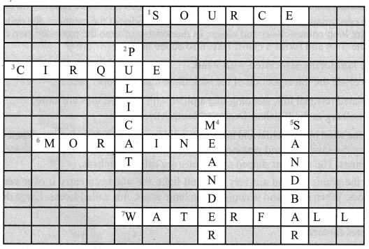
Crossword Puzzle
Across
1. Place of origin of the river.
3. Armchair shaped glacial landform
6. Glacial Depositional feature
7. Vertical drop of water
Down
2. Lagoon in Tamil Nadu
4. Loops along the river course
5. Wave depositional feature
Answer:
Question 3.
Identify any one of the following features near your home town and write a note on them.
- Hill
- Waterfall
- River(or)Stream
- Beach
Answer:
Activity to be done by the students themselves
Samacheer Kalvi 7th Social Science LandForms Additional Questions
I. Choose the correct answer:
Question 1.
The term ‘meander’ has been named on the basis of Meander River of ______
(a) India
(b) Russia
(c) China
(d) Turkey
Answer:
(d) Turkey
Question 2.
The material carried by the glacier such as rock, sand, and silt get deposited to form ______
(a) Cirque
(b) Glacial moraines
(c) Aretes
(d) Tam Lake
Answer:
(b) Glacial moraines
Question 3.
Northern China loess deposits are brought from the ______ desert.
(a) the Gobi
(b) Sahara
(c) Thar
(d) the Atacama
Answer:
(a) the Gobi
![]()
Question 4.
Steep rock faces formed due to the dashing of sea waves are ______
(a) Sea caves
(b) Sea Cliffs
(c) Sea Arches
(d) Stacks
Answer:
(b) Sea Cliffs
Question 5.
Chilka lake is Odisha is an example of ______
(a) Stack
(b) Sea Arch
(c) Lagoon
(d) Sand bar
Answer:
(c) Lagoon
II. Circle the odd one
Question 1.
Angel, Niagra, Victoria, Ganges
Hint: the Ganges are the river, the other three are waterfalls.
Answer:
Ganges
Question 2.
Colva, Miami, Chilka, Marina.
“Hint: Chilka is a lake, the other three are Beaches.
Answer:
Chilka
![]()
Question 3.
Water, Sun, ice, Sea waves.
Hint: Sun is a natural resource, the other three are agents of erosion.
Answer:
Sun
III. Match the following
| A | B | |
| Continental glacier | i | The Alps |
| Mountain glacier | ii | Vembanad lake |
| Inselberg | iii | Antarctica |
| Lagoon | iv | Kalahari |
Answer:
- iii
- i
- iv
- ii
IV. Consider the following statements.
Question 1.
- The highest waterfall is Angel falls of Venezuela in South America.
- The first longest beach in the world is the Marina beach in Chennai.
- Deltas are excellent productive lands.
Choose the correct answer using the codes given below.
(a) 1 and 3
(b) 2 and 3
(c) 1 and 2
(d) only 3.
Answer:
(a) 1 and 3
Question 2.
- A part of the land adjoining or near the sea is called the sea coast.
- The boundary of a coast where land meets water is called the coastline.
- Moraines are glacial deposition.
Choose the correct answer using the codes given below.
(a) 2 and 3
(b) 1 and 3
(c) 1,2 and 3
(d) 1 and 2.
Answer:
(c) 1, 2 and 3
V. Answer in a word
Question 1.
Name the waterfall located on the borders of Zambia and Zimbabwe in Africa
Answer:
Victoria falls
Question 2.
How is the deposition of sediment that occurs when the river enters a plain or the foothills called?
Answer:
Alluvial fan
![]()
Question 3.
What are hollow like caves formed on a rock due to the dashing of sea waves called?
Answer:
Sea caves.
VI. Answer in a sentence or two.
Question 1.
What is the endogenic process?
Answer:
The endogenic process (internal process) leads to the upliftment and sinking of the earth’s surface at several places.
Question 2.
What is the exogenic process?
Answer:
The exogenic process (external process) is the continuous wearing down and rebuilding of the land surface.
Question 3.
What is gradation?
Answer:
Graduation is the process of leveling of highlands through erosion and filling up of lowlands through a deposition.
Question 4.
Name the processes by which the landscape gets continuously worn away?
Answer:
The landscape is being continuously worn away by two processes – weathering and erosion.
Question 5.
Define weathering.
Answer:
Weathering is the breaking and falling apart into small pieces of the rocks on the earth’s surface.
![]()
Question 6.
What is the river?
Answer:
The water flowing from its source to the river mouth, along a definite course is called a River.
Question 7.
How is a delta formed? Give an example of deltas.
Answer:
The collection of sediments from all the mouths form Delta. Deltas are excellent productive lands. They have more minerals which favor cultivation. E.g. Cauvery delta, Ganges delta, Mississippi delta.
Question 8.
What is a glacier?
Answer:
A large body of ice moving slowly down a slope or valley due to gravity is called a glacier.
VII. Answer in a Paragraph.
Question 1.
Write a note on
- Sea Coast
- Coastline
Answer:
- Sea Coast: A part of the land adjoining or near the sea is called the Sea coast.
- Coastline: The boundary of the coast, where land meets water is called the Coastline. The coastal areas are subject to change due to wave erosion and wave deposition
![]()
Question 2.
Write a note on
- Sea Arches
- Stacks
Answer:
- Sea Arches: As the cavities of sea caves become bigger and bigger only the roof of the caves remains, thus forming Sea Arches.
- Stacks: Further, erosion breaks the roof and only walls are left. These wall-like features are called Stacks.