You can Download Samacheer Kalvi 10th Social Science Book Solutions Guide Pdf, Tamilnadu State Board help you to revise the complete Syllabus and score more marks in your examinations.
Tamilnadu Samacheer Kalvi 10th Social Science Geography Solutions Chapter 1 India: Location, Relief and Drainage
India: Location, Relief and Drainage TEXTUAL EXERCISE
I. Choose the correct answer.
Question 1.
The north-south extent of India is
(a) 2,500 km
(b) 2,933 km
(c) 3,214 km
(d) 2,814 km
Answer:
(c) 3,214 km
Question 2.
The Southern most point of India is:
(a) Andaman
(b) Kanyakumari
(c) Indira Point
(d) Kavaratti
Answer:
(c) Indira Point
Question 3.
The extent of Himalayas in the east-west is about
(a) 2,500 km
(b) 2,400 km
(c) 800 km
(d) 2,200 km
Answer:
(a) 2,500 km
![]()
Question 4.
……………. River is known as ‘Sorrow of Bihar’.
(a) Narmada
(b) Godavari
(c) Kosi
(d) Damodar
Answer:
(c) Kosi
Question 5.
Deccan Plateau covers an area of about ……. sq.km.
(a) 8 lakh
(b) 6 lakh
(c) 5 lakh
(d) 7 lakh
Answer:
(d) 7 lakh
![]()
Question 6.
A landmass bounded by sea on three sides is referred to as:
(a) Coast
(b) Island
(c) Peninsula
(d) Strait
Answer:
(c) Peninsula
Question 7.
The Palk Strait and Gulf of Mannar separates India from ………
(a) Goa
(b) West Bengal
(c) Sri Lanka
(d) Maldives
Answer:
(c) Sri Lanka
Question 8.
The highest peak in South India is:
(a) Ooty
(b) Kodaikanal
(c) Anaimudi
(d) Jindhagada
Answer:
(c) Anaimudi
Question 9.
………… Plains are formed by the older alluviums.
(a) Bhabar
(b) Tarai
(c) Bhangar
(d) Khadar
Answer:
(c) Bhangar
Question 10.
Pulicat Lake is located between the states of:
(a) West Bengal and Odisha
(b) Karnataka and Kerala
(c) Odisha and Andhra Pradesh
(d) Tamil Nadu and Andhra Pradesh
Answer:
(d) Tamil Nadu and Andhra Pradesh
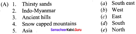
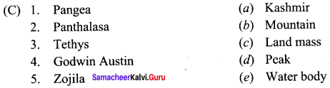
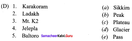
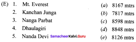
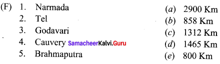
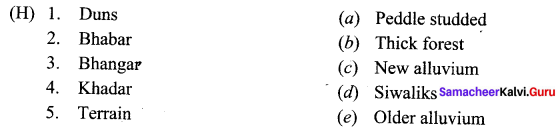
II. Match the following.
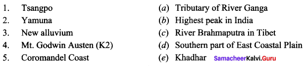
Answers:
1. (c)
2. (a)
3. (e)
4. (b)
5. (d)
III. Give Reasons.
Question 1.
The Himalayas are called young fold mountains.
Answer:
They were formed by earth movements which affected the relief of the earth in the last phase of its geological history. Because of the young age which is evident from the striking contrast in relief, Himalayan ranges are called young fold mountains.
Question 2.
North Indian Rivers are perennial.
Answer:
North Indian Rivers have their origin from the snow-covered Himalayas. As these rivers have water throughout the year they are referred to as perennial rivers.
Question 3.
Chottanagpur Plateau is rich in mineral resources.
Answer:
Chottanagpur Plateau is a store house of mineral resources such as mica, bauxite, copper, limestone, iron ore and coal.
Question 4.
The great Indian desert is called Marusthali.
Answer:
In Sanskrit Marusthali means ‘dead land’. It is the region of the actual desert with severe arid climate and very low vegetation. This region has different types of sand dunes.
![]()
Question 5.
The Eastern states are called seven sisters.
Answer:
Mizoram and Manipur are connected to the rest of India through Basak Village in Assam. And
it is due to this interdependence, they were given the sobriquet. It is a well known fact that the
states of Arunachal Pradesh, Assam, Meghalaya, Manipur, Mizoram, Nagaland and Tripura were named the seven sisters in 1972.
Question 6.
The river Godavari is often referred as Vridha Ganga.
Answer:
“Vridha” means old. It originates and flow through the Peninsular plateau, the oldest among the physiographic divisions of India. Like River Ganga,Godavari is the longest with an area of 3.13 lakh km2, among the peninsular rivers. Hence the river is often referred as “Vridha Ganga”.
IV. Distinguish between the following
Question 1.
Himalayan rivers and Peninsular rivers.
Answer:
| S.No. | Himalayan Rivers | Peninsular Rivers |
| 1. | Originate from Himalayas | Originate from Western Ghats |
| 2. | Long and wide Perennial in nature | Short and arrow |
| 3. | Perennial in nature | Non Perennial in nature |
| 4. | Unsuitable for hydropower generation | Suitable for hydropower generation |
| 5. | Middle and lower courses are navigable | Not useful for navigation |
Question 2.
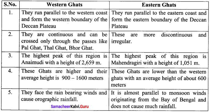
Western Ghats and Eastern Ghats.
Answer:
Question 3.
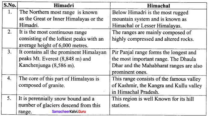
Himadri and Himachal.
Answer:
Question 4.
Western Coastal Plains and Eastern Coastal Plains.
Answer:
V. Answer in brief.
Question 1.
Name the neighbouring countries of India.
Answer:
India shares its land boundaries with Pakistan in the west, Afghanistan in the north-west, China, Nepal and Bangladesh in the east.
Our Southern neighbours across the sea consists of the two island countries, namely Sri Lanka and Maldives.
Question 2.
Give the importance of lST.
Answer:
The longitudinal extent of India between the West and the East is about 30° from Gujarat to Arunachal Pradesh. This longitudinal difference make a difference of nearly 2 hours in local time between Gujarat in the West and Arunachal Pradesh in the East. In order to avoid the time difference between the places 1ST is calculated. The Indian Standard Time is calculated based on 82°30′ East longitude.
Question 3.
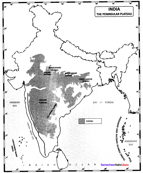
Write a short note on Deccan Plateau.
Answer:
- The Deccan Plateau is a triangular landmass that lies to the south of the river Narmada.
- This is the largest physiographic division of our country.
- It covers an area of about 16 lakh sq.km (about half of the total area of the country)
- It is an old rocky plateau region.
- The topography consists of a series of plateaus and hill ranges interspersed with river valleys.
- It is higher in the west and slopes gently eastwards.
- The Western Ghats and the Eastern Ghats mark the western and the eastern edges of the Deccan plateau respectively.
- Aravalli hills mark the north-western boundary of the plateau region.
- Its northern and north-eastern boundaries are marked by the Bundelkhand upland, Kaimur and Rajmahal hills.
- Western Ghats lie parallel to the Western coast. They are continuous and can be crossed through passes only like Thai, Bhor and the Pal Ghats. It is higher then the Eastern Ghats. It cause orographic rain by facing the rain-bearing moist winds to rise along the western slopes of the Ghats. The height of the Western Ghats progressively increases from north to south. The highest peak include the Anaimudi (2,695 metres) and the DodaBetta (2,637 metres).
- The Eastern Ghats stretch from the Mahanadi valley to the Nilgiris in the south. The Eastern Ghats are discontinuous and irregular and dissected by rivers draining into the Bay of Bengal. Mahendragiri (1,501 metres) is the highest peak in the Eastern Ghats. Shevroy Hills and the Javadi Hills are located to the southeast of the Eastern Ghats. The famous hill stations of Udagamandalam, popularly Known as Ooty and the Kodaikanal are located here.
- One of the distinct features of the peninsular plateau is the black soil area known as Deccan Trap. This is of volcanic region hence the rocks are igneous. These rocks have denuded over time and are responsible for the formation of black soil. ‘
Question 4.
State the west-flowing rivers of India.
Answer:
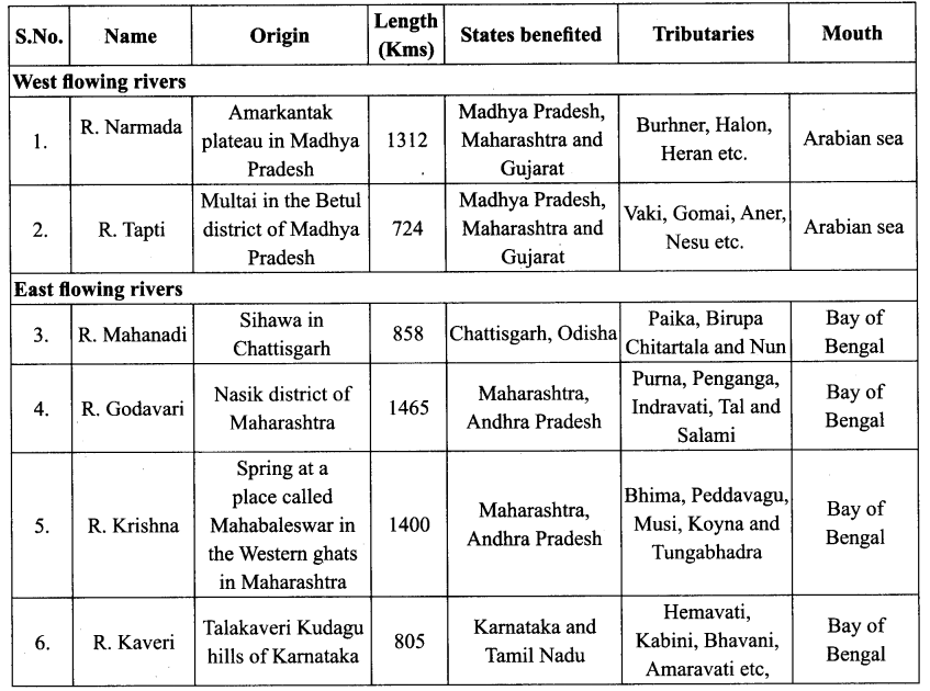
Narmadha, Tapti and Mahi are the west-flowing rivers of India. They flow into the Arabian Sea through Gulf of Cambay.
![]()
Question 5.
Write a brief note on the island group of Lakshadweep.
Answer:
- It lies close to the Malabar coast of Kerala.
- This group of islands is composed of small coral islands.
- Earlier they were known as Laccadive, Minicoy and Amindive. In 1973, these were named as Lakshadweep.
- It covers small area of 32 sq.km. Kavaratti island is the administrative headquarters of Lakshadweep.
- This island group has great diversity of flora and fauna. The Pitti island which is uninhabited, has a bird sanctuary.
VI. Answer in a paragraph.
Question 1.
Explain the divisions of the Northern Mountains and its importance to India.
Answer:
- Northern mountains are the youngest and the loftiest mountain chains in the world.
- It stretches for a distance of2500km from the Indus gorge in the West to Brahmaputra gorge in the East.
- The major divisions of the Northern mountains are:
- The Trans Himalayas
- Himalayas
- Eastern or Purvanchal hills
(i) The Trans Himalayas:
- It lies in Jammu and Kashmir and Tibetian plateau.
- It is also known as Western Himalayas. As its areal extent is more in Tibet, it is also known as Tibetean Himalayas.
- The rocks of this region are of Thethys sediments and contain fossils bearing marine sediments.
- The prominent ranges of this division are Zaskar, Ladakh, Kailash and Karakoram.
(ii) The Himalayas:
- It is formed by the uplifted compression of the Thethys sea due to tectonic forces.
- It has three parallel ranges.
(a) The Greater Himalayas (Himadri)
(b) The Lesser Himalayas (Himachal)
(c) The Outer Himalayas (Siwaliks)
(a) The Greater Himalayas or Himadri:
- The most continuous range.
- Almost all the lofty peaks of the Himalayas are located in this range.
Eg: Mt. Everest (8,848m) and Kanchenjunga (8,586m). - It is the region of permanent snow cover.
- It has many glaciers like Gangothri, Yamunothri and Siachen.
(b) The Lesser Himalayas or Himachal:
- It is the middle range of Himalayas.
- Made up of rocks like slate, limestone and quartzite.
- Important ranges pir panjal, Dhauladhar and Mahabharat.
- Familiar for hill stations – Shimla, Mussourie Nainital, Almora, Ranikhet and Daijeeling.
(c) The Outer Himalayas or Siwaliks:
- It is the most discontinuous range dissected by the Himalayan rivers.
- The longitudinal valleys found between the Siwaliks and the Himachal are called Duns in the West and Duars in the East. Eg: Dehradun.
- This range is ideal for the development of settlements.
(iii) The Eastern Himalayas or Purvanchal Hills:
- They are the Eastern off shoots of Himalayas.
- Most of these hills are located along the border of India and Myanmar.
- Some of the important hills are Patkai Bum, Naga hills, Manipur hills, Mizo hills, Garo hills, Khasi hills and Jaintia hills.
- Collectively known as Purvanchal hills.
Importance:
- Forms as the natural barrier to the Sub continent.
- Source for many perennial rivers such as Indus, Ganges and Brahmaputra.
- Paradise of tourists due to its natural beauty.
- Renowned for rich bio-diversity.
- Many hill stations and Pilgrim centres like Amamath, Kedamath, Badrinath and Vaishnavidevi temple are located.
- Natural climatic barrier prevents the cold winds from Central Asia. Blocks the South west monsoon winds and causes heavy rainfall to North India.
![]()
Question 2.
Give an account on the major peninsular rivers of India.
Answer:
- The rivers in South India are called the Peninsular rivers.
- Most of the rivers originate from the Western Ghats.
- These are seasonal rivers, (non-perennial)
- They have a large seasonal fluctuation in volume of water as they are solely fed by rain.
- These rivers flow in valleys with steep gradients.
- Based on the direction of flow, the Peninsular rivers are divided into the west flowing and east flowing rivers.
East Flowing Rivers:
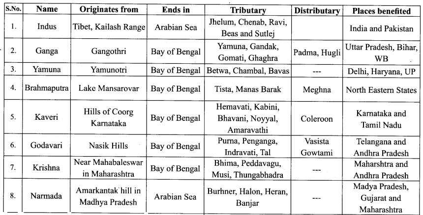
1. Mahanadi:
- It originates near Sihawa in Raipur district of Chattisgarh and flows through Odisha.
- Its length is 851 km.
- Seonath, Telen, Sandur and lb are its major tributaries.
- The main stream of Mahanadi gets divided into several distributaries such as Paika, Birupa, Chitartala, Genguti and Nun.
- The Mahanadi empties its water in Bay of Bengal.
2. Godavari:
- Godavari is the longest river (1,465 km) with an area of 3.13 lakh km2 among the Peninsular rivers.
- It is also called Vridha Ganga.
- It originates in Nasik district of Maharashtra, a portion of Western Ghats.
- It flows through the states of Telangana and Andhra Pradesh before joining Bay of Bengal.
- Puma, Penganga, Pranitha, Indravati, Tal and Salami are its major tributaries.
- The river near Rajahmundry gets divided into two Channels called Vasistha and Gautami and forms one of the largest deltas in India.
- Kolleru, a fresh water lake is located in the deltaic region of the Godavari.
3. Krishna:
- The river Krishna originates from a spring at a place called Mahabaleshwar in the Western Ghats of Maharashtra.
- Its length is 1,400 km and an area of 2.58 lakh sq km.
- It is the second longest Peninsular river Bhima, Peddavagu, Musi, Koyna and Thungab hadra are the major tributaries of this river.
- It also flows through Andhra Pradesh and joins in Bay of Bengal, at Hamasaladevi.
4. Kaveri:
- The river Kaveri originates at Talakaveri, Kudagu hills of Karnataka.
- Its length is 800 km.
- The river Kaveri is called Dhakshin Ganga or Ganga of south.
- Harangi, Hemavati, Kabini, Bhavani, Arkavathy, Noyyal, Amaravathi etc are the main tributaries of the river Kaveri.
- In Karnataka the river bifurcates twice, forming the sacred islands of Srirangapatnam and Sivasamudram.
- While entering Tamil Nadu, the Kaveri continues through a series of twisted wild gorges until it reaches Hogenakkal Falls and flows through a straight, narrow gorge near Salem.
- The Kaveri breaks at Srirangam Island with two channels, river Coleroon and Kaveri.
- At last, it empties into the Bay of Bengal at Poompuhar.
West Flowing Rivers:
1. Narmada:
- It rises in Amarkantak Plateau in Madhya Pradesh at an elevation of about 1057 m and flows for a distance of about 1,312 km.
- It covers an area of 98,796 sq km and forms 27 km long estuary before outfalling into the Arabian Sea through the Gulf of Cambay.
- It is the largest among the west flowing rivers of Peninsular India.
- Its principal tributaries are Burhner, Halon, Heran, Banjar, Dudhi, Shakkar, Tawa, Bama and Kolar.
2. Tapti:
- The Tapti is one of the major rivers of Peninsular India with the length of about 724 km.
- It covers an area of 65,145 sq km.
- Tapti river rises near Multai in the Betul district of Madhya Pradesh at an elevation of about 752 m.
- It is one of only the three rivers in Peninsular India that run from east to west – the others being the Narmada and the Mahi.
- The major tributaries are Vaki, Gomai, Arunavati, Aner, Nesu, Buray, Panjhra and Bori.
- It out falls into the Arabian Sea through the Gulf of Cambay.
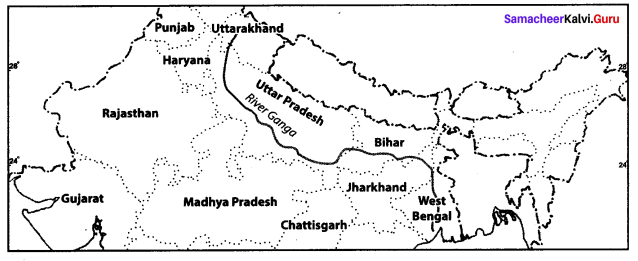
3. Give a detailed account on the basin of the Ganga.
- The Ganga River system is the largest drainage system of India.
- The river Ganga is 2,480 km long.
- It rises in the Gangotri glacier in the Himalayas at a height of 6000 metres.
- It cuts deep gorges through the Siwalik range and enters into the plain at Haridwar.
- The Ganga plain occupies an area of about 3,37,000 covering the states of Uttar Pradesh, Bihar and West Bengal.
- The river Yamuna rises in Yamunotri glacier. After flowing for a distance of about 1300 km, it joins Ganga on its right bank at Allahabad.
- The rivers Chambal, Betwa, Son and Ken rise in the Deccan Plateau and join Ganga on its right bank.
- The Ghandak, the Gomati, the Ghaghara and the Kosi join the Ganga on its left bank.
- It is covered by thick alluvial sediments.
- The Ganga plains slopes gently from Haryana and drains into Bay of Bengal.
- It is covered by thick alluvial sediments.
- The largest distributary of Ganga is Hooghly.
- Most of the Ganga Delta lies in Bangladesh.
- The Seaward of the Ganga Delta has tidal estuaries, sand banks and islands known as Sunderbans.
VII. Map exercises: Mark the following in the outline map of India
Question 1.
Major mountain ranges – Karakoram, Ladakh, Zaskar, Aravalli, Western Ghats, Eastern Ghats.
Answer:
Question 2.
Major rivers — Indus, Ganga, Brahmaputra, Narmada, Tapti, Mahanadi, Godavari, Krishna & Kaverl.
Answer:
Question 3.
Major plateaus – Malwa, Chotanagpur, Deccan.
Answer:
VIII. Activities
Question 1.
Observe the Peninsular Plateau map of India and mark the major plateau divisions of India.
Answer:
Question 2.
Prepare a table showing the major West flowing and East flowing rivers of peninsular India.
Answer:
Question 3.
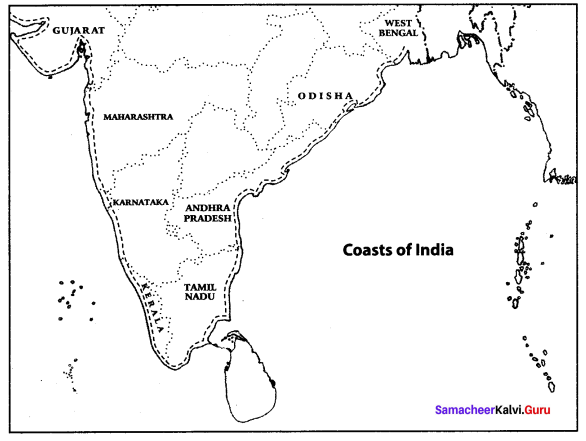
Assume that you are travelling from West Bengal to Gujarat along the beautiful coasts of India. Find out the states which you would pass through.
I will pass through the states of Odisha, Andhra Pradesh, Tamil Nadu, Kerala, Karnataka and Maharashtra.
Answer:
Question 4.
Find out the states through which the river Ganga flows.
The river Ganga flows through the states of Uttarakhand, Uttar Pradesh, Bihar, Jharkhand, and West Bengal.
Answer:
Question 5.
Prepare a table showing the major rivers in India and find out it’s tributaries, origin, length and area.
Answer:
Find Out:
Question 1.
The number of Union Territories along the Western Coast and Eastern Coast?
Answer:
- Along Western coast – Four – Diu, Daman, Dadra and Nagar Haveli, Lakshadweep islands.
- Along the Eastern coast -Two – Puducherry and Andaman and the Nicobar Islands.
Question 2.
Area wise which is the smallest and largest state?
Answer:
Largest state: Rajasthan
Smallest State: Goa
Question 3.
The states which do not have an international border or lie on the coast.
Answer:
The States that do not share an International boundary or lie on the coast are Haryana, Madhya Pradesh, Jharkhand and Chattisgarh and Telangana.
Union Territories – Chandigarh and Delhi.
![]()
Question 4.
Classify into four groups each having common frontiers with
i) Pakistan
ii) China
iii) Myanmar and
iv) Bangladesh
Answer:
Pakistan: Jammu and Kashmir, Punjab, Rajasthan and Gujarat.
China: Jammu and Kashmir, Himachal Pradesh, Sikkim and Arunachal Pradesh.
Myanmar: Arunachal Pradesh, Nagaland, Manipur, Mizoram.
Bangladesh: Bihar, West Bengal, Jharkhand, Assam, Meghalaya and Tripura.
Question 5.
Find the Hill stations which are located in Himalayan Mountains.
Answer:
Shimla, Mussourie, Nainital, Almora. Ranikhet, Darjeeling and Kulu Manali are some of the hill stations in Himalayan mountains.
![]()
Question 6.
In which river the Gerosappa (jog) fall is found?
Answer:
Sharavathi River
India: Location, Relief and Drainage Additional Questions
I. Choose the correct answer.
Question 1.
India covers an area of ………. million sq.kms.
(a) 3.2
(b) 3.5
(c) 3.8
Answer:
(a) 3.2
Question 2.
India’s longest border is with:
(a) Bangladesh
(b) Srilanka
(c) Bhutan
(d) Afghanistan
Answer:
(a) Bangladesh
![]()
Question 3.
In India, there is a vast plain in ………
(a) north
(b) south
(c) east
Answer:
(a) north
Question 4.
Till 2024 the ………………… will be the capital for both the States of Andhra pradesh and Telangana.
(a) Hyderabad
(b) Secunderabad
(c) Nellore
(d) Amaravati
Answer:
(a) Hyderabad
Question 5.
India is situated into southern part of ……….
(a) Indo-Myanmar
(b) Asia
(c) Sri Lanka
Answer:
(b) Asia
Question 6.
The ………………… ranges of the Himalayas is the most continuous of all the ranges.
(a) Himachal
(b) Aravalli
(c) Siwaliks
(d) Himadri
Answer:
(d) Himadri
Question 7.
India occupies ………. % of the world’s land area.
(a) 3.5
(b) 2.4
(c) 7.5
Answer:
(b) 2.4
Question 8.
The deltaic region of lower Ganga, the uplands are known as:
(a) Chars
(b) Bhangar
(c) Terai
(d) Bils
Answer:
(a) Chars
Question 9.
India is the ……….. largest country regarding its area.
(a) seventh
(b) third
(c) fourth
Answer:
(a) seventh
Question 10.
The ………………… river system is the largest drainage system of India.
(a) Yamuna
(b) Godavari
(c) Ganga
(d) Kaveri
Answer:
(c) Ganga
Question 11.
India is ………….. times smaller than USA.
(a) ten
(b) seven
(c) three
Answer:
(c) three
![]()
Question 12.
India has a predominant position in the ……. realm.
(a) Bay of Bengal
(b) Indian Ocean
(c) Arabian Sea
Answer:
(b) Indian Ocean
Question 13.
No other country has such a large ……….. line.
(a) mountain
(b) plateau
(c) coastal
Answer:
(c) coastal
Question 14.
India is connected with China, Japan and Australia through ………..
(a) Malaccan Strait
(b) Suez canal
(c) Palk Strait
Answer:
(a) Malaccan Strait
Question 15.
The 0° Meridian passes through Greenwich in ……………
(a) New york
(b) England
(c) Los Angeles
Answer:
(b) England
Question 16.
Dehra Dun is the capital of ………..
(a) Uttar Pradesh
(b) Sikkim
(c) Uttranchal
Answer:
(c) Uttranchal
Question 17.
India is a ……….. country with total freedom of worship.
(a) republic
(b) democratic
(c) secular
Answer:
(c) secular
Question 18.
According to gaseous mass theory, the earth was separated from the ………….
(a) Universe
(b) Sun
(c) Milky way
Answer:
(b) Sun
Question 19.
The ……… force on Tethys sea gave rise to “Himalayas”.
(a) depressional
(b) compressed
(c) longitudinal
Answer:
(b) compressed
Question 20.
The Himalayas started growing up due to ………. of the agents of denudation.
(a) deposition
(b) transportation
(c) erosion
Answer:
(c) erosion
Question 21.
The Gangetic plain was formed due to ………..
(a) erosion
(b) transportation
(c) deposition
Answer:
(c) deposition
Question 22.
The major physiographical units of India are ………
(a) six
(b) five
(c) four
Answer:
(a) six
Question 23.
The Himalayas are made of ………… rocks.
(a) sedimentary
(b) igneous
(c) volcanic
Answer:
(a) sedimentary
Question 24.
Pamir knot is in the ………… part of India.
(a) north-east
(b) north-west
(c) south-east
Answer:
(b) north-west
Question 25.
Ladakh is in the north-west of ……….
(a) Himachal Pradesh
(b) Kashmir
(c) Kerala
Answer:
(b) Kashmir
Question 26.
The northernmost range of Himalayas is ………
(a) Himachal
(b) Siwaliks
(c) Himadri
Answer:
(c) Himadri
![]()
Question 27.
Himachal is highly ………. topography.
(a) smooth
(b) rugged
(c) narrow
Answer:
(b) rugged
Question 28.
Pirpanjal lies in ……… state.
(a) Kashmir
(b) Himachal Pradesh
(c) Arunachal Pradesh
Answer:
(a) Kashmir
Question 29.
Amamath, Kedranath and Badrinath are the …….. of Himachal range.
(a) valleys
(b) hill resorts
(c) pilgrimages
Answer:
(c) pilgrimages
Question 30.
Siwaliks is the ………. range, made up of mud and soft rocks.
(a) discontinuous
(b) broad
(c) continuous
Answer:
(a) discontinuous
![]()
Question 31.
An example of longitudinal valley of Siwaliks is ………..
(a) Nainital
(b) Mussouri
(c) Dehra Dun
Answer:
(c) Dehra Dun
Question 32.
……… supports the growth of thick forest in siwaliks.
(a) Pebbles and gravels
(b) Muds and soft rock
(c) fine silt
Answer:
(c) fine silt
Question 33.
The Purvachal mountains are of ……… height.
(a) medium
(b) short
(c) very tall
Answer:
(a) medium
![]()
Question 34.
The Himalayas act as the ……. barrier protecting from the foreign invasions.
(a) physical
(b) natural
(c) climate
Answer:
(a) physical
Question 35.
…… soil helps the cultivation of crops in great plain.
(a) block
(b) alluvium
(c) fertile
Answer:
(b) alluvium
Question 36.
There are dense forests on the ……….. of the Himalayan.
(a) peak
(b) valleys
(c) slopes
Answer:
(c) slopes
![]()
Question 37.
The ……… attract the tourists by its scenic beauty and pleasant climate.
(a) hill stations
(b) pilgrimages
(c) valleys
Answer:
(a) hill stations
Question 38.
The great Plain was formed due to …….. force.
(a) compression
(b) depression
(c) longitudinal
Answer:
(b) depression
Question 39.
The depression was caused in the plains out of ………..
(a) erosion
(b) transportation
(c) deposition
Answer:
(c) deposition
Question 40.
The rivers passed their ways by eroding their ……. when Himalayas lifted themselves high.
(a) passes
(b) mountains
(c) valleys
Answers:
(c) valley
II. Fill in the blanks.
1. The land in India gets abundance sunshine from the ………. sun.
2. India is the ……….. largest country with respect to area.
3. The shallow sea divided the Angara and Gondwana land was ………
4. The south eastern part of the Deccan plateau is known as ……….
5. The description of the physical relief features of a country is known as ………
6. The Pamir Knot, popularly known as the ……….
7. Mount Everest is the highest peak of the world with an altitude of ………..
8. The largest tributary of the Ganga is ……..
9. The largest plateau of the peninsular region is ………
10. The largest and longest of the Peninsular river is …………
11. The Cauvery rises in hills of …….. district in Karnataka.
12. The ………. river rises in Agasthiar hills.
13. India is connected with Europe through ………….
14. Himalayas and Karakoram provide a ……… boundary in the north.
15. Godwin Austin known as ………. is the highest peak of India.
16. The water body around the compact land mass was called …………
17. Karakoram stretches out eastern from ………..
18. …………. is the longest glacier.
19. The gaps providing natural routes across the mountains are called …………
20. The beautiful Kashmir valley is found in ……… ranges.
21. The narrow longitudinal valleys of siwaliks are called ………..
22. A flat low lying land of the Great plain is made up of ……….
23. The ……….. is a narrow porous zone along the foothills of Siwaliks.
24. The ………. is a zone of dampers and marshes covered with forests.
25. The Indus river flows into Pakistan through ………..
26. Ganga river reaches plain at …………..
27. Dams across the rivers help in generating ……….. power.
28. The Sub division of the peninsular plateau are the …….. and the ………..
29. At the apex of the Deccan plateau is ……….
30. The other name of the Deccan plateau is ………. plateau.
31. The Passes in the Western Ghats are ………., ………. and ………
32. The rivers of the Peninsular India originate on the ……… ghats.
33. ………, ……….. are the distributaries of the cauvery.
34. ……… and ……….. of the special markages of the fast coast plain.
35. River Ganga is known as the river ………. in Bangladesh.
Answers
1. tropical
2. seventh
3. tethys
4. Telengana
5. physiography
6. Roof of the World
7. 8,848 metres
8. Hooghly
9. Deccan plateau
10. Godavari
11.coorg
12. Thamiraparani
13. suez canal
14. natural
15. Mount K2
16. Panthalasa
17. Pamir Knot
18. Siachin
19. Passes
20. dhauladhar
21. duns
22. alluvium
23. Bhabar
24. Terail
25. Kashmir
26. Haridwar
27. hydroelectric
28. Central highland, Deccan plateau
29. Kanyakumari
30. lava
31. Thai ghat, Bohr ghat, Pal ghat
32. western
33. vennar, vettar
34. Lagoons, delta
35. Padma
III. Match the following.
Answers
1. (b)
2. (c)
3. (d)
4. (e)
5. (a)
Answers:
1. (d)
2. (c)
3. (e)
4. (b)
5. (a)
Answers:
1. (c)
2. (e)
3. (b)
4. (d)
5. (a)
Answers:
1. (e)
2. (c)
3. (b)
4. (a)
5. (d)
Answers:
1. (d)
2. (c)
3. (e)
4. (a)
5. (b)
Answers:
1. (c)
2. (b)
3. (d)
4. (e)
5. (a)

Answers:
1. (d)
2. (e)
3. (b)
4. (a)
5. (c)
Answers:
1. (d)
2. (a)
3. (e)
4. (b)
5. (c)
IV. Distinguish Between:
Question 1.
Konkan Coast and Malabar Coast.
Answer:
| S.No. | Konkan Coast | Malabar Coast |
| 1. | It extent from Gujarat to Goa. | It is located between Mangalore and Kanyakumari. |
| 2. | It has some features of marine erosions like cliffs and reefs. | It contains a large number of long and narrow lagoons. |
| 3. | The Northern part is sandy and the southern part is rocky and rugged. | The lagoons and backwaters serve as inland waterways. |
Question 2.
Andaman and Nicobar Islands and Lakshadweep Islands.
Answer:
| S.No. | Andaman and Nicobar Islands | Lakshadweep Islands |
| 1. | They are located in the Bay of Bengal. | They are located in the Arabian Sea. |
| 2. | They are far off from India. | They are of coral origin. |
| 3. | Port Blair is the capital. | Kavaratti is the administration headquaters. |
| 4. | They are about 572 islands. | They are 27 islands here. |
| 5. | Only 38 are inhabited. | Only 11 islands are inhabited. |
Question 3.
The Bundelkhand and The Baghelkhand.
Answer:
| S.No. | The Bundalkhand | The Baghelkhand |
| 1. | It is located towards the south of the Yamuna river. | It lies to the east of “Maikala Range”. |
| 2. | It is composed of igneous and metamorphic rocks. | It is made up of sand stone and limestone. |
| 3. | In the northern part of it, there is rich deposit of alluvium. | The central part of the plateau acts as water divide between the Son and the Mahanadhi drainage basins. |
Question 4.
GMT and IST.
Answer:
| S.No. | GMT | IST |
| 1. | It means Greenwich Mean Time. | It means Indian Standard Time |
| 2. | GMT is calculated at 0° longitude. | India’s central meridian is 82° 30′ E longitude. |
| 3. | It passes through Greenwich. | It passes through Mirzapur. |
| 4. | It is the World Standard Time. | It is the Indian Standard Time. |
Question 5.
The Bhabar Plain and The Khadar Plain.
| S.No. | The Bhabar Plain | The Khadar Plain |
| 1. | It lies to the south of the Siwalik from west to east. | It is the new alluvium of the plains. |
| 2. | It is a pebble studded zone of porous beds. | They form a continuous belt of fresh deposits of silt every year during rainy season. |
| 3. | This plain is not suitable for cultivation. Only big trees with large roots thrive in this region | The Khadar land consists of sand, silt, clay and mud. It is highly fertile soil. |
V. Answer in One Word.
Question 1.
The tropic of Cancer does not pass through which state?
Answer:
Odisha
Question 2.
What is the easternmost longitude of India?
Answer:
97° 25′ E
![]()
Question 3.
Which latitude divides India into two equal halves?
Answer:
Tropic of Cancer (23° 30′ N)
Question 4.
Name the island group which lies towards east of India.
Answer:
Andaman and Nicobar
Question 5.
What is the percentage of land area that India occupies with respect to the world?
Answer:
2.4%
Question 6.
What is the distance between east and weat extremity of India in Kilometres?
Answer:
2933 km
Question 7.
What is the time lag from Gujarat to Arunachal Pradesh?
Answer:
2 hrs
Question 8.
The Standard Meridian of India passes through Mirzapur, it is located on which state of India.
Answer:
Uttar Pradesh
![]()
Question 9.
How much distance has been reduced between India and Europe by the construction of the Suez Canal?
Answer:
7000 km distance
Question 10.
Which is the smallest state of India area wise?
Answer:
Goa
Question 11.
What is the southernmost part of India?
Answer:
Indira Point
Question 12.
What is southernmost part of Indian mainland?
Answer:
Kanyakumari
Question 13.
Which states of India shares their border with Myanmar?
Answer:
Tripura, Mizoram, Manipur, and Nagaland.
Question 14.
Name the Eastern Coastal States of India.
Answer:
Odisha, West Bengal, Tamil Nadu, Andhra Pradesh.
![]()
Question 15.
Name the landmass bounded by sea on three sides.
Answer:
Peninsular
Question 16.
Which is the most of the volcanoes and earthquakes in the world located?
Answer:
The Peninsular Plateau
Question 17.
Name the mountain ranges in the eastern part of India forming its boundary with Myanmar.
Answer:
Purvanchal
Question 18.
What is the name given to longitudinal valley that lies between lesser Himalayas and Shivaliks?
Answer:
Duns
Question 19.
Name the part of the Himalayas lying between the Kali and Tista rivers.
Answer:
Nepal Himalayas
Question 20.
Which river has the largest inhabited riverine islands in the world?
Answer:
Brahmaputra
Question 21.
What is the soil of Bangar region that contains calcareous deposits locally known as?
Answer:
Kankar
![]()
Question 22.
What is the swampy and marshy region of Northern plains called as?
Answer:
Terai
Question 23.
What is the highest peak in the Eastern Ghats?
Answer:
Mahendragiri (1502 mt)
Question 24.
Name the second highest peak of Western Ghats.
Answer:
Doda Betta
Question 25.
Which type of soil is found in Deccan Trap region?
Answer:
Black soil
![]()
Question 26.
Name the major west flowing rivers in the peninsular plateau.
Answer:
Narmada and Tapti
Question 27.
Name the largest river of the Indian Ocean.
Answer:
Luni
Question 28.
What is the name given to the southern part of eastern coastal plains?
Answer:
Coromandel
Question 29.
Which is the largest salt water lake of India?
Answer:
Chilika
Question 30.
Which physiographic division is the storehouse of minerals?
Answer:
Peninsular Plateau
VI. Answer in brief.
Question 1.
India is a Sub-continent.
Answer:
India possesses distinct continental characteristics in physiography, climate, natural vegetation, minerals, human resources etc., Hence India is known as “Subcontinent”.
Question 2.
Mention the tributaries and distributaries of Cauvery.
Answer:
Tributaries: Amaravathi, Noyyal and Bhavani.
Distributaries: Vennar, vettar and Kudamurutti
![]()
Question 3.
Write the latitudinal and longitudinal extent of India.
Answer:
India extends from 8°4’N to 37°6 ‘N latitudes and 68°7 ‘E to 97°25 ‘E longitude. It is located in the North-Eastern hemisphere. The Tropic of cancer (23°30’N) passes through the middle of the country dividing it into two halves.
Question 4.
When did the Suez Canal start functioning and how did it benefit India?
Answer:
The Suez Canal started functioning in 1869.
Benefits of India.
- It reduced the distance between India and Europe by 7,000 km.
- The Canal in the boom for trade as it had reduced the transportation cost and number of days involved.
Question 5.
Name the major physiographic divisions of India.
Answer:
Based on the geological structure, India is divided into 6 major physiographic divisions namely.
- The Himalayan Mountains (Northern mountains)
- The Great Northern plains
- The Peninsular plateau
- The Great Indian desert
- The Coastal plains
- The Islands
Question 6.
Which features modified the relief features of India?
Answer:
Besides geological functions, a lot of processes such as weathering erosion and deposition have created and modified the relief to its present form.
Question 7.
Name the prominent ranges of Trans-Himalayas.
Answer:
The prominent ranges of Trans-Himalayas are Karakoram, Zaskar, Ladak and Kailash.
Question 8.
What is the extent of Northern plains of India?
Answer:
It spreads over an area of 7 lakh sq.km. The plain being about 2400 km long and 240 to 320 km broad.
![]()
Question 9.
What are ‘Duns’?
Answer:
The longitudinal valley found between the Siwaliks and Himachal range are called Duns in the West and Duars in the East. These are the ideal sites for human settlements and agriculture.
Question 10.
What is doab?
Answer:
A tract of land between two rivers is called a doab. It made up of two words ‘do’ meaning ‘two’ and ab meaning ‘water’.
Question 11.
To which parts are Ganga plains extended?
Answer:
The Ganga plain extends between Ghagger and Teesta rivers. It is spread over Haryana, Delhi, Uttar Pradesh, Jharkhand and West Bengal.
Question 12.
How are riverine islands formed?
Answer:
Rivers moving from mountains carry alluvium with them and do the depositional work. In the lower course because of gentle slope, the river velocity decrease, and therefore islands are formed.
Question 13.
Where is -Deccan Trap located and what does it composed of?
Answer:
The black soil area in the peninsular plateau regions is known as Deccan trap. They extend from Gujarat to Delhi in a southwest – northeast direction. This is of volcanic origin hence the rocks are igneous.
Actually these rocks have descended over time and are responsible for the formation of black soil. The Aravalli hills lie on the western and northwestern margins of the peninsular plateau. These are highly eroded hills and are found as broken hills.
![]()
Question 14.
What are Barchans?
Answer:
They are crescent shaped dunes.
Question 15.
What are the climate characteristics of Indian desert?
Answer:
The region recevies very low rainfall below 150 mm per year. Streams appear during the rainy season. Soon after they disappear into the sand as they do not have enough water to reach the sea.
VII. Answer the following in paragraph.
Question 1.
What do you mean by drainage system? Write a note on it.
Answer:
- A drainage system is an integrated system of tributaries and trunk stream which collects and drains surface water into the sea, lake or some other water body.
- The total area drained by a river and its tributaries is known as a drainage basin.
- The drainage pattern of an area is the result of the geological structure of the respective areas.
- The river system provides irrigation, drinking water, power generation and livelihood for a large number of population.
- The drainage system of India is broadly divided into two major groups on the basis of their location. They are
- The Himalayan rivers
- Peninsular rivers
Question 2.
“Unity in Diversity”. Explain.
Answer:
India is a vast country with a diversity of Physical characteristics.
Diversity in Natural Phenomena
- India has unique landforms ranging from the highest peaks to the lowest plains. In the north India, Mount Godwin Austin, otherwise known as Mt. K2 is the highest peak of India and coastal plains are the lowest in the South India.
- The Climate varies from the tropical to the temperate zone. Mawsynram in Meghalaya receives the highest amount of rainfall whereas the thar desert receives very low rainfall.
- We have wet dense tropical forest on the western Ghats, Mangrove trees in the sundarbans of West Bengal and the shrubs and sparse vegetation in the Thar desert.
- The diversity of the physical environment and climate has made India an ideal habitat for varieties of flora and fauna.
Diversity in Natural Phenomena
India is a secular country with total freedom of worship. People follow Hinduism, Christianity, Islam, Sikkism, Buddhism, Jainism and Zoroastrianism with cultural diversities.
Unity in Diversity
Inspite of its physical, religion and racial varities, the ‘Indian Culture’ unites all people. Hence India is known for her “Unity in diversity”.
People shed all their differences and stand together when is a crisis. The best examples are kargil invasions and natural calamities like floods and Tsunami. Even if we differ in many factors, we are all one in the fact we are Indians.
![]()
Question 3.
Give an account on Punjab-Haryana plains.
Answer:
- Punjab Haryana plains are one among the subdivisions of the Northern plains.
- They are formed by the deposition of the rivers Sutlej, Beas and Ravi, the tributaries of River Indus.
- They lie to the North-east of the Great Indian Desert.
- These plains are found over an area of about 1.75 lakh sq.km.
- These plains act as water-divide (Doab) to the rivers Yamuna-Sutlej and Ganga-Yamuna.
![]()
Question 4.
Explain the origin of the Himalayas.
Answer:
- Millions of years ago there was only one landmass on the surface of the earth. It was surrounded by ocean on all sides.
- The landmass was called “ Pangea”. It was surrounded by a waterbody Known as “Panthalasa”.
- This large landmass split up into two parts. The northern part was known as “Angaraland” and the southern part was known as “Gondwana land”.
- The Sea seperating these two was called the Tethys Sea.
- This Sea stretched along an east-west direction.
- The rivers from Angara and Gondwana deposited the silts along the Tethys Sea.
- After a long period, due to tectonic forces the deposits up lifted to forms fold mountains called the Himalayan range.
- It is an young fold mountain.
- The Himalayas is the home of several high peak. However, it holds the record of having the maximum number of highest peaks among any mountains range in world. Out of the heights peaks in this world, Himalayas holds nine.
Question 5.
Give an account of the four divisions of Himalayas from west to east along with Purvanchal hills respectively.
Answer:
Divisions of the Himalayas of the basis of regions from west to east. These division have been demarcated by river valleys.
(i) Punjab Himalayas:
The part of the Himalayas lying between Indus and Sutlej has been traditionally known as Punjab Himalayas but it is also known as regionally as Kashmir and Himachal Himalaya from west to east respectively.
(ii) Kumaon Himalayas:
The part of the Himalayas lying between Satluj and Kali rivers is known as Kumaun Himalayas.
(iii) Assam Himalayas:
The Kali and Tista rivers demarcate the Nepal Himalayas and the past lying between Tista and Dihang rivers is known as Assam Himalayas.
Purvachal:
- The Brahmaputra marks the eastern most boundary of the Himalayas. Beyond the Dihang gorge, the Himalayas bend sharply to the south and spread along the eastern boundary of India. They are known as Purvanchal or the Eastern hills and mountains.
- These hills running through the north-eastern states are mostly composed of strong sandstones which are sedimentary rocks.
- It covered with dense forests, they mostly runs as parallel ranges and valleys.
- The Purvanchal comprises the Patkai hills, the Naga hills, Manipur hills and the Mizo hills.
Question 6.
Give a detailed account on the Great Northern Plains.
Answer:
Formation:
The Northern Plain has been formed by the interplay of the three major river systems namely – The Indus, The Ganga, and The Brahmaputra along with their tributaries. This plain is formed of alluvial soil. The deposition of alluvium in a vast basis lying of the foothills of the Himalayas over millions of years formed this fertile plain.
Extension:
It spread over an area of 7 lakh sq.km. The plain being about 2400 km long and 240 to 320 km broad, is a densely populated physiographic division.
Importance:
With a rich soil caves combined with adequate water supply and favourable climate it is agriculturally a very production past of India.
Important Features:
- In the lower course, due to gentle slope, the velocity of the river decreases which results in the formation of riverine islands. Majuli, in the Brahmaputra River is the largest inhabited riverine island in the world.
- The rivers in their lower course split into numerous channels due to the deposition of silt. These channels are known as tributaries.
- The Northern Plain is broadly divided into three sections. Punjab plains, Ganga plains and Brahmaputra plains.
- According to the variations in relief features, the Northern plains can be divided into four regions – Bhabar, Terai, Bhangar and Khadar.
Punjab Plains:
The Western part of the Northern plain is referred to as the Punjab plains formed by the Indus and its tributaries. The larger part of this plain lies in Pakistan Indus and its tributaries – The Jhelum, the Chenab, the Ravi, the Beas and the Satluj originate in the Himalayas. This section of the plain is dominated by the doabs.
Ganga Plains:
They extend between Ghagger and Teesta rivers. It is spread over the states of North India like Haryana, Delhi, U.P., Bihar, Partly Jharkhand and West Bengal.
Brahmaputra plains:
In the east of Ganga plains lies the Brahmaputra plains. They cover the areas of Assam and Arunachal Pradesh.
According to the variations in relief features, the Northern plains can be divided into four regions.
Bhabar:
The rivers after descending from the mountains deposit pebbles in a narrow belt of about 8 to 16 km in width lying parallel to the slopes of the Shivaliks. It is known as Bhabar. All the streams disappear in this Bhabar belt.
Terai:
South of this belt, the streams and rivers re-emerge and create a wet swampy and marshy region known as ‘Terai’. This was a thickly forested region full of wildlife.
The Terai is wider in the eastern parts of the Great plains, especially in Brahmaputra valley due to heavy rainfall. In many states, the Terai forest have been cleaned for cultivation.
Khadar:
The newer younger deposits of the flood plains are called Khadar. They are renamed almost every year and so are fertile. Thus ideal for intensive agriculture. The Khadar tracts are enriched by fresh deposits of silt every year during rainy seasons. The Khadar land consists of sand, silt, clay and mud. It is highly fertile soil.
Delta Plains:
The deitaic plains is an extension of the Khadar land. It covers about 1.9 sq.km in the lower reaches of the Ganga River. It is an area of deposition as the river flows in this tract sluggishly. The deltaic plain consists mainly of old mud, new mud and marsh. In the delta region, the uplands are called “chars”. While the marshy areas are called ‘Bils’
Question 7.
Write in brief about Peninsular Plateau.
Answer:
Location:
- The Peninsular plateau is located to the south of northern great plains.
- It covers an area of about 16 lakh sq.km.
- Boundaries of the Peninsular plateau.
- North – Aravalli, Vindhya, Satpura and Rajmahal ranges
- West – Western Ghats
- East – Eastern Ghats
- The average height varies between 600 – 900 mts above the mean sea level.
- The general slope is from west to east broad divisions, namely the Central Highlands and the Deccan Plateau.
Central Highlands:
- The part of the Peninsular plateau lying to the north of the Narmada river covering a major area of the Malwa Plateau is known as the Central Highlands
Malwa Plateau:
- Malwa Plateau is bounded by the Aravalli range, the Vindhya range and Bundelthand.
- The Chambal river and its tributaries have created ravines in the northern part of the plateau.
The Bundelkhand:
- It is located towards the south of the Yamuna river.
- It is composed of igneous and metamorphic rocks.
- In the northern part, the Ganga and Yamuna rivers have deposited alluvium.
- The hilly areas are made up of sandstone and granite.
- Betwa and Ken rivers have carved out deep gorges.
The Baghelkhand:
- It lies to the east of “Maikala Range”.
- It is made up of sandstone and limestone in the west and granite in the east.
- The central part of the plateau acts as water divide between the Son and the Mahanadhi drainage system.
The Chotanagpur Plateau:
- It is located towards the northeast.
- It is drained by Damodar, Sabamarekha, Koel and Barakar rivers.
- The Damodar river flows from west to east through the middle of this region.
- This region has a series of plateau and hills.
Deccan Plateau:
- It is made up of lava and is covered with black soil.
Boundaries of Deccan Plateau.- North-east – Vindhya and Satpura mountains
- North – Mahadev and Maikala range
- West – Western Ghats
- East – Eastern Ghats
- It is a tableland composed of the old crystalline, igneous and metamorphic rocks.
- It is formed due to the breaking and drifting of the Gondwana land.
- It has broad and shallow valleys and rounded hills.
- It is a triangular landmass that lies to the south of the river Narmada.
- The Satpura range flanks its broad base in the north while the Mahadev, the Kaimur hills and the Maikal range form its eastern extensions.
- The Deccan plateau is higher in the weat and slopes gently eastwards.
- Rivers like Mahanadhi, Godavari, Krishna and Kaveri flow eastwards and join the Bay of Bengal.
- It is separated by a fault from the Chotanagpur plateau.
- It made up of lava rocks and has black regur soils.
![]()
Question 8.
Write about the Indian Desert.
Answer:
- The Indian desert lies towards the western margins of the Aravalli Hills.
- It is an undulating sandy plain covered with sand dunes.
- This regions receives very low rainfall below 150 mm per year.
- It has arid climate with low vegetation cover.
- Streams appear during the rainy season, soon after they disappear into the sand as they do not have enough water to reach the sea. Luni is the only large rivers in this region.
- Barchans (Crescent-shaped dunes) covers large areas more prominent in Jaisalmer but longitudinal dunes become more prominent near the Indo-Pakistan boundary.
- It is the world 7th largest desert and world 9th largest sub tropical desert located in western part of the India.
- There are two major division on the Thar desert. They are known as the Actual desert region (Marusthali) and the semi desert region (Bhangar).
Question 9.
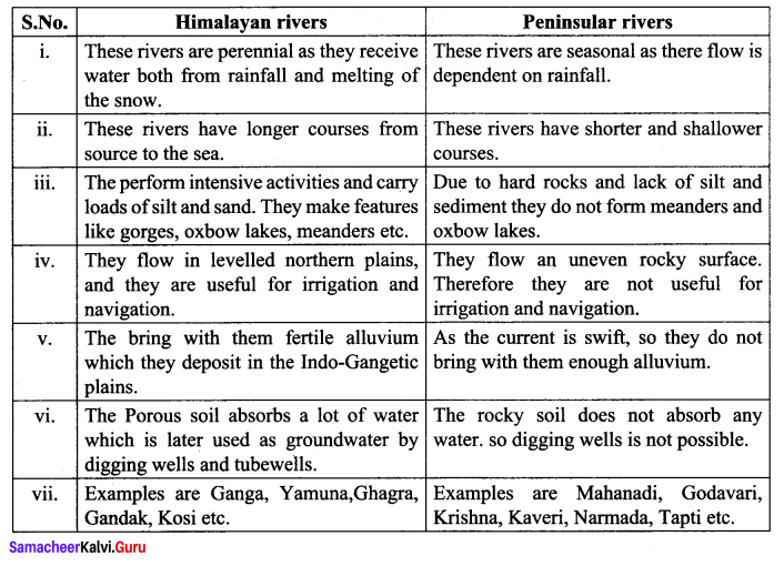
Differences between Himalayan rivers and Peninsular rivers.
Answer: